Udanin geodata
Udanin (Lower Silesia) is a seat of a third-order administrative division; located in Poland in Europe/Warsaw (GMT+2) time zone. With population of 982 people, there are 2530 cities with bigger population in this country. Compared to other cities in Poland, 54.3% of cities are located further ↑North; 89.8% of cities are located further →East and 52.3% of cities have lower elevation than Udanin. Note1


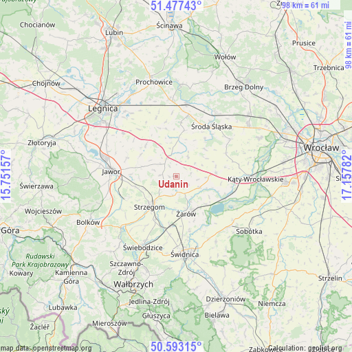
Udanin GPS coordinates[2]
51° 2' 14.64" North, 16° 27' 16.884" East
| Map corner | latitude | longitude |
|---|---|---|
| Upper-left | 51.47743°, | 15.75157° |
| Center: | 51.0374°, | 16.45469° |
| Lower-right: | 50.59315°, | 17.15782° |
| Map W x H: | 98.3×98.3 km | = 61.1×61.1mi |
| max Lat: | 54.83135° ⇑54.3% North |
| Udanin: | 51.0374° |
| min Lat: | ⇓45.7% South 49.21328° |
| min Long | Udanin | max Long |
| 14.20249° | 16.45469° | 24.03723° |
| W 10.2%⇐ | ⇒89.8% E |
Elevation
Elevation of Udanin is 178 m = 584 ft, and this is 13.4 m = 44 ft below average elevation for this country.
| Max E: |
974 m = 3196 ft | 47.7% |
| Avg. | 191.4 m = 628 ft | |
| Udanin | 178 m = 584 ft | |
Min E: |
-3 m = -10 ft | 52.3% |
See also: Poland elevation on elevation.city.
Geographical zone
Udanin is located in North temperate zone (between Tropic of Cancer and the Arctic Circle). Distance of this North polar circle is 1726.3 km =1072.7 mi to North.| Distance of | km | miles | from Udanin |
|---|---|---|---|
| North Pole | 4332.2 | 2691.9 | to North |
| Arctic Circle | 1726.3 | 1072.7 | to North |
| Tropic Cancer | 3068.9 | 1906.9 | to South |
| Equator | 5674.8 | 3526.2 | to South |


Nearby cities:
15 places around Udanin: (largest is in red/bold)
• Ciechów
13.2 km =8.2 mi,  36°
36°
• Dobromierz
20.5 km =12.7 mi,  226°
226°
• Jawor
18.3 km =11.4 mi,  274°
274°
• Jaworzyna Śląska
13.9 km =8.6 mi,  186°
186°
• Konary
4.4 km =2.7 mi,  275°
275°
• Kostomłoty
10.9 km =6.8 mi,  85°
85°
• Legnickie Pole
19 km =11.8 mi,  308°
308°
• Malczyce
20.5 km =12.7 mi,  7°
7°
• Marcinowice
19.7 km =12.2 mi,  152°
152°
• Mierczyce
11.6 km =7.2 mi,  302°
302°
• Stanowice
13.1 km =8.1 mi,  205°
205°
• Strzegom
11.1 km =6.9 mi,  221°
221°
• Wądroże Wielkie
12.3 km =7.6 mi,  315°
315°
• Środa Śląska
17.2 km =10.7 mi,  34°
34°
• Żarów
11.1 km =6.9 mi,  165°
165°
Sources, notices
• [Note1] Compared only with cities in Poland existing in our database
• [Src1] Map data: © OpenStreetMap contributors (CC-BY-SA)
• [Src2] Other city data from geonames.org with taken over terms of usage.
• [Src3] Geographical zone / Annual Mean Temperature by Robert A. Rohde @ Wikipedia
