Sędziszów geodata
Sędziszów (Świętokrzyskie) is a seat of a third-order administrative division; located in Poland in Europe/Warsaw (GMT+2) time zone. With population of 6,771 people, there are 555 cities with bigger population in this country. Compared to other cities in Poland, 66% of cities are located further ↑North; 59.2% of cities are located further ←West and 76.8% of cities have lower elevation than Sędziszów. Note1


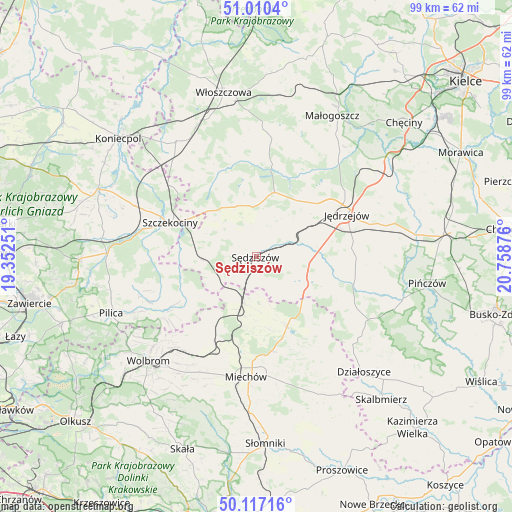
Sędziszów GPS coordinates[2]
50° 33' 57.24" North, 20° 3' 20.268" East
| Map corner | latitude | longitude |
|---|---|---|
| Upper-left | 51.0104°, | 19.35251° |
| Center: | 50.5659°, | 20.05563° |
| Lower-right: | 50.11716°, | 20.75876° |
| Map W x H: | 99.3×99.3 km | = 61.7×61.7mi |
| max Lat: | 54.83135° ⇑66% North |
| Sędziszów: | 50.5659° |
| min Lat: | ⇓34% South 49.21328° |
| min Long | Sędziszów | max Long |
| 14.20249° | 20.05563° | 24.03723° |
| W 59.2%⇐ | ⇒40.8% E |
Elevation
Elevation of Sędziszów is 253 m = 830 ft, and this is 61.6 m = 202 ft above average elevation for this country.
| Max E: |
974 m = 3196 ft | 23.2% |
| Sędziszów | 253 m 830 ft | |
| Avg. | 191.4 m = 628 ft | |
Min E: |
-3 m = -10 ft | 76.8% |
See also: Poland elevation on elevation.city.
Geographical zone
Sędziszów is located in North temperate zone (between Tropic of Cancer and the Arctic Circle). Distance of this North polar circle is 1778.8 km =1105.3 mi to North.| Distance of | km | miles | from Sędziszów |
|---|---|---|---|
| North Pole | 4384.7 | 2724.5 | to North |
| Arctic Circle | 1778.8 | 1105.3 | to North |
| Tropic Cancer | 3016.5 | 1874.4 | to South |
| Equator | 5622.4 | 3493.6 | to South |


Nearby cities:
15 places around Sędziszów: (largest is in red/bold)
• Goleniowy
14.7 km =9.1 mi,  300°
300°
• Jędrzejów
19.4 km =12.1 mi,  65°
65°
• Kozłów
9.4 km =5.8 mi,  193°
193°
• Książ Wielki
14.9 km =9.3 mi,  156°
156°
• Kępie
14.6 km =9.1 mi,  215°
215°
• Marcinowice
8.2 km =5.1 mi,  211°
211°
• Moskorzew
12.3 km =7.6 mi,  316°
316°
• Nagłowice
13 km =8.1 mi,  16°
16°
• Oksa
18.4 km =11.4 mi,  9°
9°
• Potok Wielki
12.7 km =7.9 mi, 72°
• Radków
17.2 km =10.7 mi,  343°
343°
• Szczekociny
17.6 km =10.9 mi,  292°
292°
• Słupia
6.9 km =4.3 mi, 304°
• Wodzisław
10.8 km =6.7 mi,  117°
117°
• Żarnowiec
16.8 km =10.4 mi,  234°
234°
Sources, notices
• [Note1] Compared only with cities in Poland existing in our database
• [Src1] Map data: © OpenStreetMap contributors (CC-BY-SA)
• [Src2] Other city data from geonames.org with taken over terms of usage.
• [Src3] Geographical zone / Annual Mean Temperature by Robert A. Rohde @ Wikipedia
