Potok Wielki geodata
Potok Wielki (Świętokrzyskie) is a populated place; located in Poland in Europe/Warsaw (GMT+2) time zone. With population of 609 people, there are 3256 cities with bigger population in this country. Compared to other cities in Poland, 65% of cities are located further ↑North; 61.5% of cities are located further ←West and 72.8% of cities have lower elevation than Potok Wielki. Note1


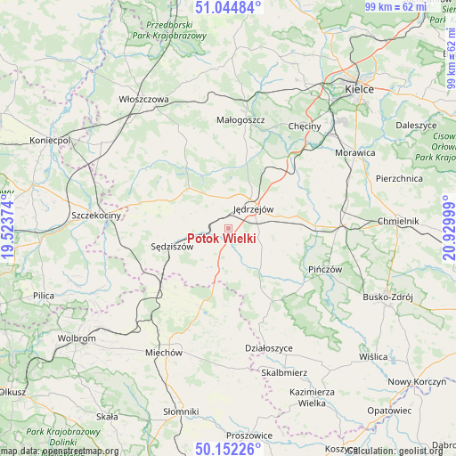
Potok Wielki GPS coordinates[2]
50° 36' 2.412" North, 20° 13' 36.696" East
| Map corner | latitude | longitude |
|---|---|---|
| Upper-left | 51.04484°, | 19.52374° |
| Center: | 50.60067°, | 20.22686° |
| Lower-right: | 50.15226°, | 20.92999° |
| Map W x H: | 99.2×99.2 km | = 61.6×61.6mi |
| max Lat: | 54.83135° ⇑65% North |
| Potok Wielki: | 50.60067° |
| min Lat: | ⇓35% South 49.21328° |
| min Long | Potok Wielki | max Long |
| 14.20249° | 20.22686° | 24.03723° |
| W 61.5%⇐ | ⇒38.5% E |
Elevation
Elevation of Potok Wielki is 239 m = 784 ft, and this is 47.6 m = 156 ft above average elevation for this country.
| Max E: |
974 m = 3196 ft | 27.2% |
| Potok Wielki | 239 m 784 ft | |
| Avg. | 191.4 m = 628 ft | |
Min E: |
-3 m = -10 ft | 72.8% |
See also: Poland elevation on elevation.city.
Geographical zone
Potok Wielki is located in North temperate zone (between Tropic of Cancer and the Arctic Circle). Distance of this North polar circle is 1774.9 km =1102.9 mi to North.| Distance of | km | miles | from Potok Wielki |
|---|---|---|---|
| North Pole | 4380.8 | 2722.1 | to North |
| Arctic Circle | 1774.9 | 1102.9 | to North |
| Tropic Cancer | 3020.3 | 1876.7 | to South |
| Equator | 5626.3 | 3496 | to South |


Nearby cities:
15 places around Potok Wielki: (largest is in red/bold)
• Imielno
15.7 km =9.8 mi,  96°
96°
• Jędrzejów
7 km =4.3 mi,  51°
51°
• Korytnica
21.3 km =13.2 mi,  72°
72°
• Kozłów
19.3 km =12 mi,  227°
227°
• Książ Wielki
18.5 km =11.5 mi,  199°
199°
• Marcinowice
19.6 km =12.2 mi,  236°
236°
• Michałów
20.3 km =12.6 mi,  125°
125°
• Moskorzew
21.1 km =13.1 mi,  284°
284°
• Nagłowice
12.1 km =7.5 mi,  315°
315°
• Oksa
16.8 km =10.4 mi,  328°
328°
• Radków
21.1 km =13.1 mi,  306°
306°
• Sobków
19.3 km =12 mi,  55°
55°
• Sędziszów
12.7 km =7.9 mi,  252°
252°
• Słupia
17.8 km =11.1 mi,  270°
270°
• Wodzisław
9.3 km =5.8 mi, 195°
Sources, notices
• [Note1] Compared only with cities in Poland existing in our database
• [Src1] Map data: © OpenStreetMap contributors (CC-BY-SA)
• [Src2] Other city data from geonames.org with taken over terms of usage.
• [Src3] Geographical zone / Annual Mean Temperature by Robert A. Rohde @ Wikipedia
