Łukta geodata
Łukta (Warmia-Masuria) is a populated place; located in Poland in Europe/Warsaw (GMT+2) time zone. With population of 1,000 people, there are 2459 cities with bigger population in this country. Compared to other cities in Poland, 92.3% of cities are located further ↓South; 59.6% of cities are located further ←West and 82.2% of cities have higher elevation than Łukta. Note1


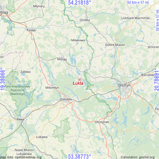
Łukta GPS coordinates[2]
53° 48' 18.036" North, 20° 5' 1.608" East
| Map corner | latitude | longitude |
|---|---|---|
| Upper-left | 54.21818°, | 19.38066° |
| Center: | 53.80501°, | 20.08378° |
| Lower-right: | 53.38773°, | 20.78691° |
| Map W x H: | 92.3×92.3 km | = 57.4×57.4mi |
| max Lat: | 54.83135° ⇑7.7% North |
| Łukta: | 53.80501° |
| min Lat: | ⇓92.3% South 49.21328° |
| min Long | Łukta | max Long |
| 14.20249° | 20.08378° | 24.03723° |
| W 59.6%⇐ | ⇒40.4% E |
Elevation
Elevation of Łukta is 95 m = 312 ft, and this is 96.4 m = 316 ft below average elevation for this country.
| Max E: |
974 m = 3196 ft | 82.2% |
| Avg. | 191.4 m = 628 ft | |
| Łukta | 95 m = 312 ft | |
Min E: |
-3 m = -10 ft | 17.8% |
See also: Poland elevation on elevation.city.
Geographical zone
Łukta is located in North temperate zone (between Tropic of Cancer and the Arctic Circle). Distance of this North polar circle is 1418.6 km =881.5 mi to North.| Distance of | km | miles | from Łukta |
|---|---|---|---|
| North Pole | 4024.5 | 2500.7 | to North |
| Arctic Circle | 1418.6 | 881.5 | to North |
| Tropic Cancer | 3376.6 | 2098.1 | to South |
| Equator | 5982.6 | 3717.4 | to South |


Nearby cities:
15 places around Łukta: (largest is in red/bold)
• Dobre Miasto
28.8 km =17.9 mi,  45°
45°
• Dywity
26.1 km =16.2 mi,  82°
82°
• Gietrzwałd
12 km =7.5 mi,  122°
122°
• Jonkowo
15.1 km =9.4 mi, 80°
• Kortowo
25 km =15.5 mi,  102°
102°
• Małdyty
25.7 km =16 mi,  299°
299°
• Miłakowo
22.7 km =14.1 mi,  357°
357°
• Miłomłyn
16.8 km =10.4 mi,  254°
254°
• Morąg
16.2 km =10.1 mi,  320°
320°
• Olsztyn
27.1 km =16.8 mi, 95°
• Olsztynek
27.9 km =17.3 mi,  151°
151°
• Ostróda
14.4 km =8.9 mi,  212°
212°
• Spręcowo
24.7 km =15.3 mi,  70°
70°
• Stawiguda
26.5 km =16.5 mi,  128°
128°
• Świątki
17.1 km =10.6 mi,  37°
37°
Sources, notices
• [Note1] Compared only with cities in Poland existing in our database
• [Src1] Map data: © OpenStreetMap contributors (CC-BY-SA)
• [Src2] Other city data from geonames.org with taken over terms of usage.
• [Src3] Geographical zone / Annual Mean Temperature by Robert A. Rohde @ Wikipedia
