Borne Sulinowo geodata
Borne Sulinowo (West Pomerania) is a seat of a third-order administrative division; located in Poland in Europe/Warsaw (GMT+2) time zone. With population of 4,349 people, there are 760 cities with bigger population in this country. Compared to other cities in Poland, 90.4% of cities are located further ↓South; 89.3% of cities are located further →East and 62.1% of cities have higher elevation than Borne Sulinowo. Note1
Administrative division(s):
- Level 1: West Pomerania
- Level 2: Powiat szczecinecki
- Level 3: Borne Sulinowo


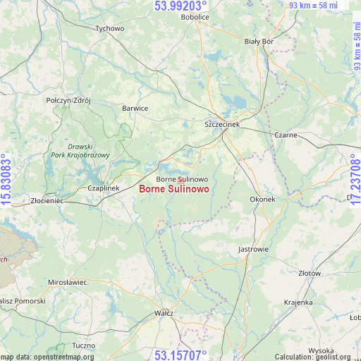
Borne Sulinowo GPS coordinates[2]
53° 34' 35.796" North, 16° 32' 2.22" East
| Map corner | latitude | longitude |
|---|---|---|
| Upper-left | 53.99203°, | 15.83083° |
| Center: | 53.57661°, | 16.53395° |
| Lower-right: | 53.15707°, | 17.23708° |
| Map W x H: | 92.8×92.8 km | = 57.7×57.7mi |
| max Lat: | 54.83135° ⇑9.6% North |
| Borne Sulinowo: | 53.57661° |
| min Lat: | ⇓90.4% South 49.21328° |
| min Long | Borne Sulinowo | max Long |
| 14.20249° | 16.53395° | 24.03723° |
| W 10.7%⇐ | ⇒89.3% E |
Elevation
Elevation of Borne Sulinowo is 142 m = 466 ft, and this is 49.4 m = 162 ft below average elevation for this country.
| Max E: |
974 m = 3196 ft | 62.1% |
| Avg. | 191.4 m = 628 ft | |
| Borne Sulinowo | 142 m = 466 ft | |
Min E: |
-3 m = -10 ft | 37.9% |
See also: Poland elevation on elevation.city.
Geographical zone
Borne Sulinowo is located in North temperate zone (between Tropic of Cancer and the Arctic Circle). Distance of this North polar circle is 1444 km =897.3 mi to North.| Distance of | km | miles | from Borne Sulinowo |
|---|---|---|---|
| North Pole | 4049.9 | 2516.5 | to North |
| Arctic Circle | 1444 | 897.3 | to North |
| Tropic Cancer | 3351.2 | 2082.3 | to South |
| Equator | 5957.2 | 3701.6 | to South |


Nearby cities:
15 places around Borne Sulinowo: (largest is in red/bold)
• Barwice
22.1 km =13.7 mi,  327°
327°
• Czaplinek
20 km =12.4 mi,  263°
263°
• Czarne
29.2 km =18.1 mi,  65°
65°
• Grzmiąca
29.7 km =18.5 mi,  347°
347°
• Jastrowie
25.6 km =15.9 mi,  132°
132°
• Lędyczek
28.6 km =17.8 mi,  98°
98°
• Okonek
21.5 km =13.4 mi, 102°
• Sitno
12.5 km =7.8 mi,  43°
43°
• Sypniewo
13 km =8.1 mi,  158°
158°
• Szczecinek
18.2 km =11.3 mi, 36°
• Tarnówka
33.6 km =20.9 mi,  141°
141°
• Wałcz
33.5 km =20.8 mi,  187°
187°
• Wierzchowo
31.5 km =19.6 mi,  245°
245°
• Łubowo
9.4 km =5.8 mi,  276°
276°
• Żółtnica
21.1 km =13.1 mi,  59°
59°
Sources, notices
• [Note1] Compared only with cities in Poland existing in our database
• [Src1] Map data: © OpenStreetMap contributors (CC-BY-SA)
• [Src2] Other city data from geonames.org with taken over terms of usage.
• [Src3] Geographical zone / Annual Mean Temperature by Robert A. Rohde @ Wikipedia
