Konary geodata
Konary (Lower Silesia) is a populated place; located in Poland in Europe/Warsaw (GMT+2) time zone. With population of 505 people, there are 3528 cities with bigger population in this country. Compared to other cities in Poland, 54.2% of cities are located further ↑North; 90.2% of cities are located further →East and 59.4% of cities have lower elevation than Konary. Note1


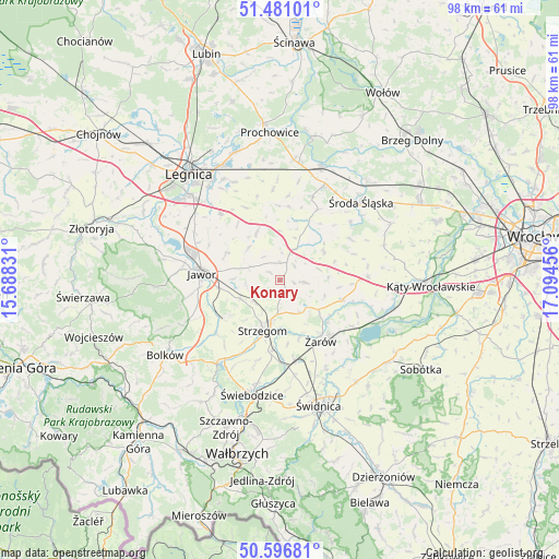
Konary GPS coordinates[2]
51° 2' 27.672" North, 16° 23' 29.148" East
| Map corner | latitude | longitude |
|---|---|---|
| Upper-left | 51.48101°, | 15.68831° |
| Center: | 51.04102°, | 16.39143° |
| Lower-right: | 50.59681°, | 17.09456° |
| Map W x H: | 98.3×98.3 km | = 61.1×61.1mi |
| max Lat: | 54.83135° ⇑54.2% North |
| Konary: | 51.04102° |
| min Lat: | ⇓45.8% South 49.21328° |
| min Long | Konary | max Long |
| 14.20249° | 16.39143° | 24.03723° |
| W 9.8%⇐ | ⇒90.2% E |
Elevation
Elevation of Konary is 199 m = 653 ft, and this is 7.6 m = 25 ft above average elevation for this country.
| Max E: |
974 m = 3196 ft | 40.6% |
| Konary | 199 m 653 ft | |
| Avg. | 191.4 m = 628 ft | |
Min E: |
-3 m = -10 ft | 59.4% |
See also: Poland elevation on elevation.city.
Geographical zone
Konary is located in North temperate zone (between Tropic of Cancer and the Arctic Circle). Distance of this North polar circle is 1725.9 km =1072.4 mi to North.| Distance of | km | miles | from Konary |
|---|---|---|---|
| North Pole | 4331.8 | 2691.7 | to North |
| Arctic Circle | 1725.9 | 1072.4 | to North |
| Tropic Cancer | 3069.3 | 1907.2 | to South |
| Equator | 5675.2 | 3526.4 | to South |


Nearby cities:
15 places around Konary: (largest is in red/bold)
• Ciechów
15.9 km =9.9 mi,  50°
50°
• Dobromierz
17.8 km =11.1 mi,  216°
216°
• Jawor
13.9 km =8.6 mi,  274°
274°
• Jaworzyna Śląska
14.5 km =9 mi,  168°
168°
• Kostomłoty
15.3 km =9.5 mi,  87°
87°
• Legnickie Pole
15.5 km =9.6 mi,  317°
317°
• Mierczyce
7.9 km =4.9 mi, 316°
• Paszowice
17 km =10.6 mi,  258°
258°
• Stanowice
12.3 km =7.6 mi,  185°
185°
• Strzegom
9.2 km =5.7 mi,  198°
198°
• Udanin
4.4 km =2.7 mi,  95°
95°
• Wądroże Wielkie
9.4 km =5.8 mi,  333°
333°
• Środa Śląska
19.7 km =12.2 mi, 46°
• Świebodzice
20.8 km =12.9 mi, 194°
• Żarów
13.2 km =8.2 mi,  146°
146°
Sources, notices
• [Note1] Compared only with cities in Poland existing in our database
• [Src1] Map data: © OpenStreetMap contributors (CC-BY-SA)
• [Src2] Other city data from geonames.org with taken over terms of usage.
• [Src3] Geographical zone / Annual Mean Temperature by Robert A. Rohde @ Wikipedia
