Łańcut geodata
Łańcut (Subcarpathian) is a seat of a second-order administrative division; located in Poland in Europe/Warsaw (GMT+2) time zone. With population of 18,266 people, there are 270 cities with bigger population in this country. Compared to other cities in Poland, 79.3% of cities are located further ↑North; 87.7% of cities are located further ←West and 70.6% of cities have lower elevation than Łańcut. Note1


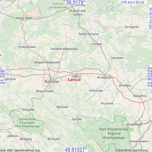
Łańcut GPS coordinates[2]
50° 4' 7.356" North, 22° 13' 44.832" East
| Map corner | latitude | longitude |
|---|---|---|
| Upper-left | 50.5179°, | 21.526° |
| Center: | 50.06871°, | 22.22912° |
| Lower-right: | 49.61527°, | 22.93225° |
| Map W x H: | 100.4×100.4 km | = 62.4×62.4mi |
| max Lat: | 54.83135° ⇑79.3% North |
| Łańcut: | 50.06871° |
| min Lat: | ⇓20.7% South 49.21328° |
| min Long | Łańcut | max Long |
| 14.20249° | 22.22912° | 24.03723° |
| W 87.7%⇐ | ⇒12.3% E |
Elevation
Elevation of Łańcut is 231 m = 758 ft, and this is 39.6 m = 130 ft above average elevation for this country.
| Max E: |
974 m = 3196 ft | 29.4% |
| Łańcut | 231 m 758 ft | |
| Avg. | 191.4 m = 628 ft | |
Min E: |
-3 m = -10 ft | 70.6% |
See also: Poland elevation on elevation.city.
Geographical zone
Łańcut is located in North temperate zone (between Tropic of Cancer and the Arctic Circle). Distance of this North polar circle is 1834.1 km =1139.7 mi to North.| Distance of | km | miles | from Łańcut |
|---|---|---|---|
| North Pole | 4439.9 | 2758.8 | to North |
| Arctic Circle | 1834.1 | 1139.7 | to North |
| Tropic Cancer | 2961.2 | 1840 | to South |
| Equator | 5567.1 | 3459.2 | to South |


Nearby cities:
15 places around Łańcut: (largest is in red/bold)
• Albigowa
6.1 km =3.8 mi,  183°
183°
• Białobrzegi
7.4 km =4.6 mi,  59°
59°
• Czarna
5.7 km =3.5 mi,  323°
323°
• Głuchów
3.3 km =2.1 mi, 64°
• Handzlówka
8.2 km =5.1 mi, 183°
• Kosina
7.1 km =4.4 mi,  86°
86°
• Kraczkowa
5.5 km =3.4 mi,  231°
231°
• Krasne
10.3 km =6.4 mi,  262°
262°
• Krzemienica
3.5 km =2.2 mi, 258°
• Markowa
8.7 km =5.4 mi,  122°
122°
• Rakszawa
10.2 km =6.3 mi,  3°
3°
• Rogóźno
10.4 km =6.5 mi, 86°
• Sonina
2.7 km =1.7 mi,  108°
108°
• Wysoka
3.5 km =2.2 mi,  140°
140°
• Wólka Podleśna
10 km =6.2 mi,  303°
303°
Sources, notices
• [Note1] Compared only with cities in Poland existing in our database
• [Src1] Map data: © OpenStreetMap contributors (CC-BY-SA)
• [Src2] Other city data from geonames.org with taken over terms of usage.
• [Src3] Geographical zone / Annual Mean Temperature by Robert A. Rohde @ Wikipedia
