Pasym geodata
Pasym (Warmia-Masuria) is a seat of a third-order administrative division; located in Poland in Europe/Warsaw (GMT+2) time zone. With population of 2,539 people, there are 1227 cities with bigger population in this country. Compared to other cities in Poland, 91% of cities are located further ↓South; 68.9% of cities are located further ←West and 62.1% of cities have higher elevation than Pasym. Note1


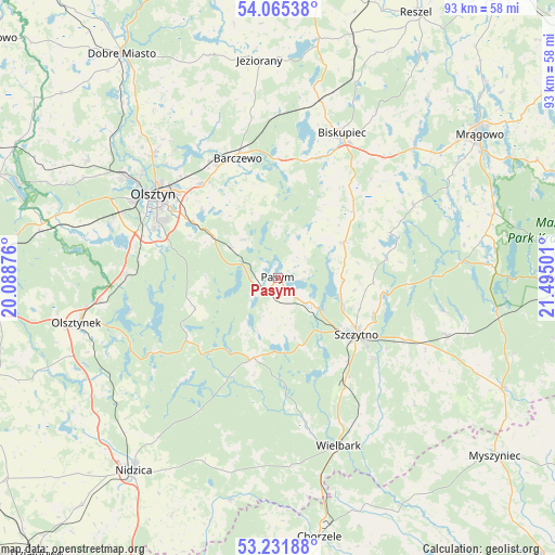
Pasym GPS coordinates[2]
53° 39' 2.484" North, 20° 47' 30.768" East
| Map corner | latitude | longitude |
|---|---|---|
| Upper-left | 54.06538°, | 20.08876° |
| Center: | 53.65069°, | 20.79188° |
| Lower-right: | 53.23188°, | 21.49501° |
| Map W x H: | 92.7×92.7 km | = 57.6×57.6mi |
| max Lat: | 54.83135° ⇑9% North |
| Pasym: | 53.65069° |
| min Lat: | ⇓91% South 49.21328° |
| min Long | Pasym | max Long |
| 14.20249° | 20.79188° | 24.03723° |
| W 68.9%⇐ | ⇒31.1% E |
Elevation
Elevation of Pasym is 142 m = 466 ft, and this is 49.4 m = 162 ft below average elevation for this country.
| Max E: |
974 m = 3196 ft | 62.1% |
| Avg. | 191.4 m = 628 ft | |
| Pasym | 142 m = 466 ft | |
Min E: |
-3 m = -10 ft | 37.9% |
See also: Poland elevation on elevation.city.
Geographical zone
Pasym is located in North temperate zone (between Tropic of Cancer and the Arctic Circle). Distance of this North polar circle is 1435.8 km =892.2 mi to North.| Distance of | km | miles | from Pasym |
|---|---|---|---|
| North Pole | 4041.7 | 2511.4 | to North |
| Arctic Circle | 1435.8 | 892.2 | to North |
| Tropic Cancer | 3359.5 | 2087.5 | to South |
| Equator | 5965.4 | 3706.7 | to South |


Nearby cities:
15 places around Pasym: (largest is in red/bold)
• Barczewo
21.1 km =13.1 mi,  341°
341°
• Biskupiec
26.1 km =16.2 mi,  24°
24°
• Czerwonka
30.3 km =18.8 mi,  13°
13°
• Dywity
29.3 km =18.2 mi,  315°
315°
• Dźwierzuty
12.6 km =7.8 mi,  61°
61°
• Jabłonka
23 km =14.3 mi,  222°
222°
• Jedwabno
14.1 km =8.8 mi,  197°
197°
• Kortowo
25.1 km =15.6 mi,  298°
298°
• Olsztyn
24.3 km =15.1 mi,  306°
306°
• Purda
8.5 km =5.3 mi, 318°
• Sorkwity
31.5 km =19.6 mi,  46°
46°
• Stawiguda
25.8 km =16 mi,  271°
271°
• Szczytno
16.2 km =10.1 mi,  127°
127°
• Wielbark
29.8 km =18.5 mi,  159°
159°
• Świętajno
29.5 km =18.3 mi,  108°
108°
Sources, notices
• [Note1] Compared only with cities in Poland existing in our database
• [Src1] Map data: © OpenStreetMap contributors (CC-BY-SA)
• [Src2] Other city data from geonames.org with taken over terms of usage.
• [Src3] Geographical zone / Annual Mean Temperature by Robert A. Rohde @ Wikipedia
