Kończyce geodata
Kończyce (Subcarpathian) is a seat of a third-order administrative division; located in Poland in Europe/Warsaw (GMT+2) time zone. With population of 384 people, there are 3599 cities with bigger population in this country. Compared to other cities in Poland, 68.9% of cities are located further ↑North; 86.9% of cities are located further ←West and 51.9% of cities have higher elevation than Kończyce. Note1


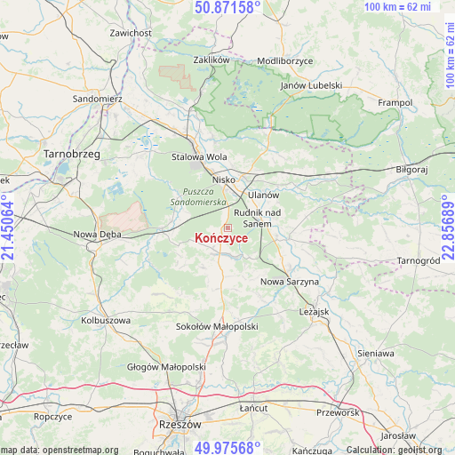
Kończyce GPS coordinates[2]
50° 25' 32.7" North, 22° 9' 13.536" East
| Map corner | latitude | longitude |
|---|---|---|
| Upper-left | 50.87158°, | 21.45064° |
| Center: | 50.42575°, | 22.15376° |
| Lower-right: | 49.97568°, | 22.85689° |
| Map W x H: | 99.6×99.6 km | = 61.9×61.9mi |
| max Lat: | 54.83135° ⇑68.9% North |
| Kończyce: | 50.42575° |
| min Lat: | ⇓31.1% South 49.21328° |
| min Long | Kończyce | max Long |
| 14.20249° | 22.15376° | 24.03723° |
| W 86.9%⇐ | ⇒13.1% E |
Elevation
Elevation of Kończyce is 167 m = 548 ft, and this is 24.4 m = 80 ft below average elevation for this country.
| Max E: |
974 m = 3196 ft | 51.9% |
| Avg. | 191.4 m = 628 ft | |
| Kończyce | 167 m = 548 ft | |
Min E: |
-3 m = -10 ft | 48.1% |
See also: Poland elevation on elevation.city.
Geographical zone
Kończyce is located in North temperate zone (between Tropic of Cancer and the Arctic Circle). Distance of this North polar circle is 1794.4 km =1115 mi to North.| Distance of | km | miles | from Kończyce |
|---|---|---|---|
| North Pole | 4400.2 | 2734.2 | to North |
| Arctic Circle | 1794.4 | 1115 | to North |
| Tropic Cancer | 3000.9 | 1864.7 | to South |
| Equator | 5606.8 | 3483.9 | to South |


Nearby cities:
15 places around Kończyce: (largest is in red/bold)
• Bieliny
10.9 km =6.8 mi,  80°
80°
• Cholewiana Góra
10.1 km =6.3 mi,  213°
213°
• Gwoździec
12.8 km =8 mi,  244°
244°
• Jeżowe
6 km =3.7 mi,  198°
198°
• Kamień
9.6 km =6 mi,  187°
187°
• Nisko
10.5 km =6.5 mi,  354°
354°
• Przędzel
9 km =5.6 mi,  31°
31°
• Racławice
9.8 km =6.1 mi,  4°
4°
• Rudnik nad Sanem
6.9 km =4.3 mi, 75°
• Tarnogóra
13.3 km =8.3 mi,  118°
118°
• Ulanów
10.6 km =6.6 mi,  47°
47°
• Wólka Tanewska
11.2 km =7 mi,  42°
42°
• Wólka Łętowska
12 km =7.5 mi,  161°
161°
• Zarzecze
11.7 km =7.3 mi,  14°
14°
• Łętownia
12.6 km =7.8 mi,  153°
153°
Sources, notices
• [Note1] Compared only with cities in Poland existing in our database
• [Src1] Map data: © OpenStreetMap contributors (CC-BY-SA)
• [Src2] Other city data from geonames.org with taken over terms of usage.
• [Src3] Geographical zone / Annual Mean Temperature by Robert A. Rohde @ Wikipedia
