Bieliny geodata
Bieliny (Subcarpathian) is a populated place; located in Poland in Europe/Warsaw (GMT+2) time zone. With population of 1,061 people, there are 2396 cities with bigger population in this country. Compared to other cities in Poland, 68.5% of cities are located further ↑North; 88.9% of cities are located further ←West and 52.5% of cities have higher elevation than Bieliny. Note1


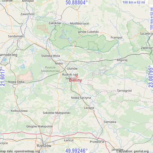
Bieliny GPS coordinates[2]
50° 26' 32.532" North, 22° 18' 17.352" East
| Map corner | latitude | longitude |
|---|---|---|
| Upper-left | 50.88804°, | 21.6017° |
| Center: | 50.44237°, | 22.30482° |
| Lower-right: | 49.99246°, | 23.00795° |
| Map W x H: | 99.6×99.6 km | = 61.9×61.9mi |
| max Lat: | 54.83135° ⇑68.5% North |
| Bieliny: | 50.44237° |
| min Lat: | ⇓31.5% South 49.21328° |
| min Long | Bieliny | max Long |
| 14.20249° | 22.30482° | 24.03723° |
| W 88.9%⇐ | ⇒11.1% E |
Elevation
Elevation of Bieliny is 165 m = 541 ft, and this is 26.4 m = 87 ft below average elevation for this country.
| Max E: |
974 m = 3196 ft | 52.5% |
| Avg. | 191.4 m = 628 ft | |
| Bieliny | 165 m = 541 ft | |
Min E: |
-3 m = -10 ft | 47.5% |
See also: Poland elevation on elevation.city.
Geographical zone
Bieliny is located in North temperate zone (between Tropic of Cancer and the Arctic Circle). Distance of this North polar circle is 1792.5 km =1113.8 mi to North.| Distance of | km | miles | from Bieliny |
|---|---|---|---|
| North Pole | 4398.4 | 2733 | to North |
| Arctic Circle | 1792.5 | 1113.8 | to North |
| Tropic Cancer | 3002.7 | 1865.8 | to South |
| Equator | 5608.7 | 3485.1 | to South |


Nearby cities:
15 places around Bieliny: (largest is in red/bold)
• Bystre
9.6 km =6 mi,  137°
137°
• Harasiuki
12.4 km =7.7 mi,  72°
72°
• Jarocin
13.6 km =8.5 mi,  4°
4°
• Kończyce
10.9 km =6.8 mi,  260°
260°
• Krzeszów
5 km =3.1 mi,  148°
148°
• Nowa Sarzyna
13.8 km =8.6 mi,  168°
168°
• Przędzel
8.4 km =5.2 mi,  313°
313°
• Racławice
12.7 km =7.9 mi, 308°
• Rudnik nad Sanem
4 km =2.5 mi,  268°
268°
• Tarnogóra
8.3 km =5.2 mi, 173°
• Ulanów
6.1 km =3.8 mi,  331°
331°
• Wólka Tanewska
7.1 km =4.4 mi, 334°
• Zarzecze
12.3 km =7.6 mi,  320°
320°
• Łukowa
13.8 km =8.6 mi,  160°
160°
• Łętownia
14 km =8.7 mi,  201°
201°
Sources, notices
• [Note1] Compared only with cities in Poland existing in our database
• [Src1] Map data: © OpenStreetMap contributors (CC-BY-SA)
• [Src2] Other city data from geonames.org with taken over terms of usage.
• [Src3] Geographical zone / Annual Mean Temperature by Robert A. Rohde @ Wikipedia
