Końskie geodata
Końskie (Świętokrzyskie) is a seat of a second-order administrative division; located in Poland in Europe/Warsaw (GMT+2) time zone. With population of 20,756 people, there are 235 cities with bigger population in this country. Compared to other cities in Poland, 50.7% of cities are located further ↓South; 63.8% of cities are located further ←West and 75.8% of cities have lower elevation than Końskie. Note1


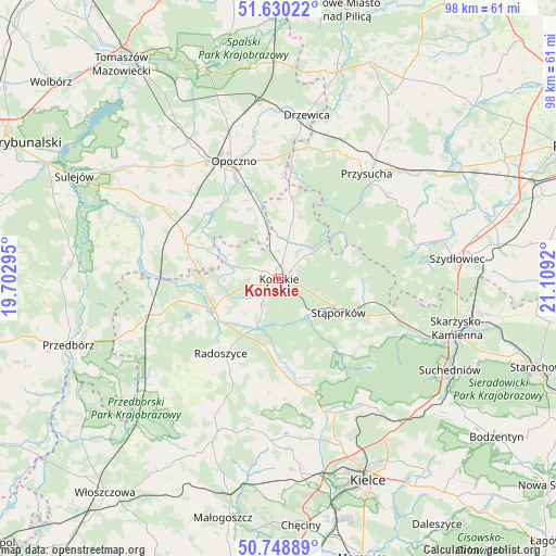
Końskie GPS coordinates[2]
51° 11' 29.976" North, 20° 24' 21.852" East
| Map corner | latitude | longitude |
|---|---|---|
| Upper-left | 51.63022°, | 19.70295° |
| Center: | 51.19166°, | 20.40607° |
| Lower-right: | 50.74889°, | 21.1092° |
| Map W x H: | 98×98 km | = 60.9×60.9mi |
| max Lat: | 54.83135° ⇑49.3% North |
| Końskie: | 51.19166° |
| min Lat: | ⇓50.7% South 49.21328° |
| min Long | Końskie | max Long |
| 14.20249° | 20.40607° | 24.03723° |
| W 63.8%⇐ | ⇒36.2% E |
Elevation
Elevation of Końskie is 249 m = 817 ft, and this is 57.6 m = 189 ft above average elevation for this country.
| Max E: |
974 m = 3196 ft | 24.2% |
| Końskie | 249 m 817 ft | |
| Avg. | 191.4 m = 628 ft | |
Min E: |
-3 m = -10 ft | 75.8% |
See also: Poland elevation on elevation.city.
Geographical zone
Końskie is located in North temperate zone (between Tropic of Cancer and the Arctic Circle). Distance of this North polar circle is 1709.2 km =1062 mi to North.| Distance of | km | miles | from Końskie |
|---|---|---|---|
| North Pole | 4315.1 | 2681.3 | to North |
| Arctic Circle | 1709.2 | 1062 | to North |
| Tropic Cancer | 3086.1 | 1917.6 | to South |
| Equator | 5692 | 3536.8 | to South |


Nearby cities:
15 places around Końskie: (largest is in red/bold)
• Białaczów
14.1 km =8.8 mi,  327°
327°
• Fałków
21.8 km =13.5 mi,  253°
253°
• Gowarczów
9.9 km =6.2 mi,  13°
13°
• Mniów
20.7 km =12.9 mi,  164°
164°
• Mroczków Gościnny
21 km =13 mi,  357°
357°
• Opoczno
22.3 km =13.9 mi,  336°
336°
• Radoszyce
16.7 km =10.4 mi,  218°
218°
• Rogów
2.4 km =1.5 mi,  55°
55°
• Ruda Maleniecka
13.7 km =8.5 mi, 248°
• Smyków
16.4 km =10.2 mi,  181°
181°
• Stąporków
13 km =8.1 mi,  117°
117°
• Wielka Wieś
12.9 km =8 mi,  91°
91°
• Wola Załężna
23.2 km =14.4 mi, 344°
• Świerczów
17.8 km =11.1 mi, 118°
• Żarnów
17.2 km =10.7 mi,  290°
290°
Sources, notices
• [Note1] Compared only with cities in Poland existing in our database
• [Src1] Map data: © OpenStreetMap contributors (CC-BY-SA)
• [Src2] Other city data from geonames.org with taken over terms of usage.
• [Src3] Geographical zone / Annual Mean Temperature by Robert A. Rohde @ Wikipedia
