Wielka Wieś geodata
Wielka Wieś (Świętokrzyskie) is a populated place; located in Poland in Europe/Warsaw (GMT+2) time zone. With population of 650 people, there are 3162 cities with bigger population in this country. Compared to other cities in Poland, 50.7% of cities are located further ↓South; 66.3% of cities are located further ←West and 90% of cities have lower elevation than Wielka Wieś. Note1


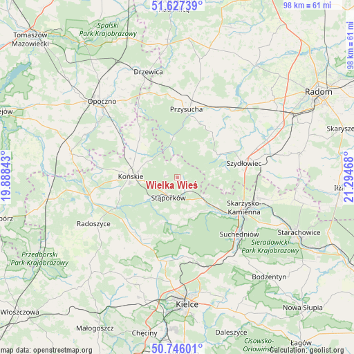
Wielka Wieś GPS coordinates[2]
51° 11' 19.716" North, 20° 35' 29.58" East
| Map corner | latitude | longitude |
|---|---|---|
| Upper-left | 51.62739°, | 19.88843° |
| Center: | 51.18881°, | 20.59155° |
| Lower-right: | 50.74601°, | 21.29468° |
| Map W x H: | 98×98 km | = 60.9×60.9mi |
| max Lat: | 54.83135° ⇑49.3% North |
| Wielka Wieś: | 51.18881° |
| min Lat: | ⇓50.7% South 49.21328° |
| min Long | Wielka Wieś | max Long |
| 14.20249° | 20.59155° | 24.03723° |
| W 66.3%⇐ | ⇒33.7% E |
Elevation
Elevation of Wielka Wieś is 328 m = 1076 ft, and this is 136.6 m = 448 ft above average elevation for this country.
| Max E: |
974 m = 3196 ft | 10% |
| Wielka Wieś | 328 m 1076 ft | |
| Avg. | 191.4 m = 628 ft | |
Min E: |
-3 m = -10 ft | 90% |
See also: Poland elevation on elevation.city.
Geographical zone
Wielka Wieś is located in North temperate zone (between Tropic of Cancer and the Arctic Circle). Distance of this North polar circle is 1709.5 km =1062.2 mi to North.| Distance of | km | miles | from Wielka Wieś |
|---|---|---|---|
| North Pole | 4315.4 | 2681.5 | to North |
| Arctic Circle | 1709.5 | 1062.2 | to North |
| Tropic Cancer | 3085.7 | 1917.4 | to South |
| Equator | 5691.7 | 3536.7 | to South |


Nearby cities:
15 places around Wielka Wieś: (largest is in red/bold)
• Bliżyn
14.8 km =9.2 mi,  127°
127°
• Borkowice
16 km =9.9 mi,  23°
23°
• Chlewiska
13.8 km =8.6 mi,  63°
63°
• Gowarczów
14.6 km =9.1 mi,  313°
313°
• Końskie
12.9 km =8 mi,  271°
271°
• Mniów
21 km =13 mi,  200°
200°
• Pawłów
17.2 km =10.7 mi,  65°
65°
• Przysucha
19.1 km =11.9 mi,  7°
7°
• Rogów
11.1 km =6.9 mi,  278°
278°
• Skarżysko-Kamienna
21.3 km =13.2 mi,  113°
113°
• Smyków
20.9 km =13 mi,  219°
219°
• Stąporków
5.9 km =3.7 mi,  193°
193°
• Suchedniów
22.8 km =14.2 mi, 133°
• Szydłowiec
19.3 km =12 mi,  76°
76°
• Świerczów
8.6 km =5.3 mi,  161°
161°
Sources, notices
• [Note1] Compared only with cities in Poland existing in our database
• [Src1] Map data: © OpenStreetMap contributors (CC-BY-SA)
• [Src2] Other city data from geonames.org with taken over terms of usage.
• [Src3] Geographical zone / Annual Mean Temperature by Robert A. Rohde @ Wikipedia
