Sobków geodata
Sobków (Świętokrzyskie) is a seat of a third-order administrative division; located in Poland in Europe/Warsaw (GMT+2) time zone. With population of 870 people, there are 2725 cities with bigger population in this country. Compared to other cities in Poland, 62.6% of cities are located further ↑North; 64.4% of cities are located further ←West and 61.9% of cities have lower elevation than Sobków. Note1


Sobków GPS coordinates[2]
50° 41' 59.964" North, 20° 27' 2.232" East
| Map corner | latitude | longitude |
|---|---|---|
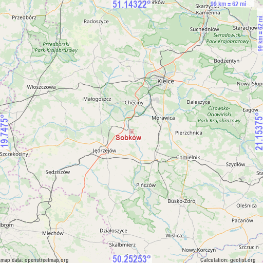
| Upper-left | 51.14322°, | 19.7475° |
| Center: | 50.69999°, | 20.45062° |
| Lower-right: | 50.25253°, | 21.15375° |
| Map W x H: | 99×99 km | = 61.5×61.5mi |
| max Lat: | 54.83135° ⇑62.6% North |
| Sobków: | 50.69999° |
| min Lat: | ⇓37.4% South 49.21328° |
| min Long | Sobków | max Long |
| 14.20249° | 20.45062° | 24.03723° |
| W 64.4%⇐ | ⇒35.6% E |
Elevation
Elevation of Sobków is 205 m = 673 ft, and this is 13.6 m = 45 ft above average elevation for this country.
| Max E: |
974 m = 3196 ft | 38.1% |
| Sobków | 205 m 673 ft | |
| Avg. | 191.4 m = 628 ft | |
Min E: |
-3 m = -10 ft | 61.9% |
See also: Poland elevation on elevation.city.
Geographical zone
Sobków is located in North temperate zone (between Tropic of Cancer and the Arctic Circle). Distance of this North polar circle is 1763.9 km =1096 mi to North.| Distance of | km | miles | from Sobków |
|---|---|---|---|
| North Pole | 4369.8 | 2715.3 | to North |
| Arctic Circle | 1763.9 | 1096 | to North |
| Tropic Cancer | 3031.4 | 1883.6 | to South |
| Equator | 5637.3 | 3502.9 | to South |


Nearby cities:
15 places around Sobków: (largest is in red/bold)
• Brzeziny
11.8 km =7.3 mi,  46°
46°
• Chęciny
11.2 km =7 mi,  4°
4°
• Imielno
12.7 km =7.9 mi,  180°
180°
• Jędrzejów
12.3 km =7.6 mi,  236°
236°
• Kije
13.4 km =8.3 mi,  140°
140°
• Korytnica
6.5 km =4 mi, 135°
• Małogoszcz
18.1 km =11.2 mi,  313°
313°
• Morawica
12.9 km =8 mi,  66°
66°
• Osiedle-Nowiny
14.6 km =9.1 mi,  25°
25°
• Piekoszów
20.1 km =12.5 mi, 2°
• Pierzchnica
21.4 km =13.3 mi,  90°
90°
• Pińczów
20.7 km =12.9 mi,  164°
164°
• Potok Wielki
19.3 km =12 mi, 235°
• Siedlce
5.7 km =3.5 mi, 31°
• Łukowa
6.8 km =4.2 mi, 65°
Sources, notices
• [Note1] Compared only with cities in Poland existing in our database
• [Src1] Map data: © OpenStreetMap contributors (CC-BY-SA)
• [Src2] Other city data from geonames.org with taken over terms of usage.
• [Src3] Geographical zone / Annual Mean Temperature by Robert A. Rohde @ Wikipedia
