Jędrzejów geodata
Jędrzejów (Świętokrzyskie) is a seat of a second-order administrative division; located in Poland in Europe/Warsaw (GMT+2) time zone. With population of 16,792 people, there are 293 cities with bigger population in this country. Compared to other cities in Poland, 64.2% of cities are located further ↑North; 62.7% of cities are located further ←West and 73.8% of cities have lower elevation than Jędrzejów. Note1


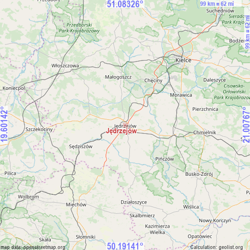
Jędrzejów GPS coordinates[2]
50° 38' 22.02" North, 20° 18' 16.344" East
| Map corner | latitude | longitude |
|---|---|---|
| Upper-left | 51.08326°, | 19.60142° |
| Center: | 50.63945°, | 20.30454° |
| Lower-right: | 50.19141°, | 21.00767° |
| Map W x H: | 99.2×99.2 km | = 61.6×61.6mi |
| max Lat: | 54.83135° ⇑64.2% North |
| Jędrzejów: | 50.63945° |
| min Lat: | ⇓35.8% South 49.21328° |
| min Long | Jędrzejów | max Long |
| 14.20249° | 20.30454° | 24.03723° |
| W 62.7%⇐ | ⇒37.3% E |
Elevation
Elevation of Jędrzejów is 242 m = 794 ft, and this is 50.6 m = 166 ft above average elevation for this country.
| Max E: |
974 m = 3196 ft | 26.2% |
| Jędrzejów | 242 m 794 ft | |
| Avg. | 191.4 m = 628 ft | |
Min E: |
-3 m = -10 ft | 73.8% |
See also: Poland elevation on elevation.city.
Geographical zone
Jędrzejów is located in North temperate zone (between Tropic of Cancer and the Arctic Circle). Distance of this North polar circle is 1770.6 km =1100.2 mi to North.| Distance of | km | miles | from Jędrzejów |
|---|---|---|---|
| North Pole | 4376.5 | 2719.4 | to North |
| Arctic Circle | 1770.6 | 1100.2 | to North |
| Tropic Cancer | 3024.7 | 1879.5 | to South |
| Equator | 5630.6 | 3498.7 | to South |


Nearby cities:
15 places around Jędrzejów: (largest is in red/bold)
• Chęciny
21 km =13 mi,  31°
31°
• Imielno
11.8 km =7.3 mi,  120°
120°
• Kije
19.1 km =11.9 mi,  100°
100°
• Korytnica
15 km =9.3 mi,  81°
81°
• Małogoszcz
19.4 km =12.1 mi,  351°
351°
• Michałów
19.5 km =12.1 mi,  145°
145°
• Nagłowice
14.6 km =9.1 mi,  287°
287°
• Oksa
17.4 km =10.8 mi,  304°
304°
• Pińczów
20.5 km =12.7 mi,  130°
130°
• Potok Wielki
7 km =4.3 mi,  231°
231°
• Siedlce
17.6 km =10.9 mi,  48°
48°
• Sobków
12.3 km =7.6 mi,  56°
56°
• Sędziszów
19.4 km =12.1 mi,  245°
245°
• Wodzisław
15.5 km =9.6 mi,  211°
211°
• Łukowa
19 km =11.8 mi, 60°
Sources, notices
• [Note1] Compared only with cities in Poland existing in our database
• [Src1] Map data: © OpenStreetMap contributors (CC-BY-SA)
• [Src2] Other city data from geonames.org with taken over terms of usage.
• [Src3] Geographical zone / Annual Mean Temperature by Robert A. Rohde @ Wikipedia
