Łukowa geodata
Łukowa (Świętokrzyskie) is a populated place; located in Poland in Europe/Warsaw (GMT+2) time zone. With population of 810 people, there are 2835 cities with bigger population in this country. Compared to other cities in Poland, 62.2% of cities are located further ↑North; 65.5% of cities are located further ←West and 75.5% of cities have lower elevation than Łukowa. Note1


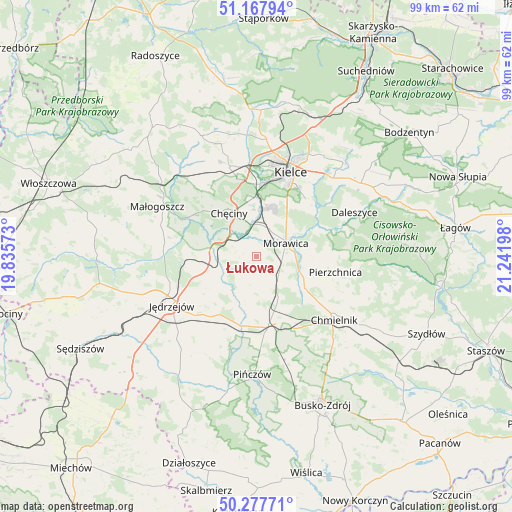
Łukowa GPS coordinates[2]
50° 43' 29.784" North, 20° 32' 19.86" East
| Map corner | latitude | longitude |
|---|---|---|
| Upper-left | 51.16794°, | 19.83573° |
| Center: | 50.72494°, | 20.53885° |
| Lower-right: | 50.27771°, | 21.24198° |
| Map W x H: | 99×99 km | = 61.5×61.5mi |
| max Lat: | 54.83135° ⇑62.2% North |
| Łukowa: | 50.72494° |
| min Lat: | ⇓37.8% South 49.21328° |
| min Long | Łukowa | max Long |
| 14.20249° | 20.53885° | 24.03723° |
| W 65.5%⇐ | ⇒34.5% E |
Elevation
Elevation of Łukowa is 248 m = 814 ft, and this is 56.6 m = 186 ft above average elevation for this country.
| Max E: |
974 m = 3196 ft | 24.5% |
| Łukowa | 248 m 814 ft | |
| Avg. | 191.4 m = 628 ft | |
Min E: |
-3 m = -10 ft | 75.5% |
See also: Poland elevation on elevation.city.
Geographical zone
Łukowa is located in North temperate zone (between Tropic of Cancer and the Arctic Circle). Distance of this North polar circle is 1761.1 km =1094.3 mi to North.| Distance of | km | miles | from Łukowa |
|---|---|---|---|
| North Pole | 4367 | 2713.5 | to North |
| Arctic Circle | 1761.1 | 1094.3 | to North |
| Tropic Cancer | 3034.2 | 1885.4 | to South |
| Equator | 5640.1 | 3504.6 | to South |


Nearby cities:
15 places around Łukowa: (largest is in red/bold)
• Brzeziny
5.8 km =3.6 mi,  24°
24°
• Chmielnik
19.4 km =12.1 mi,  129°
129°
• Chęciny
10 km =6.2 mi,  327°
327°
• Domaszowice
19.5 km =12.1 mi,  31°
31°
• Imielno
16.8 km =10.4 mi,  202°
202°
• Jędrzejów
19 km =11.8 mi,  240°
240°
• Kielce
17.3 km =10.7 mi, 21°
• Kije
13.3 km =8.3 mi,  170°
170°
• Korytnica
7.6 km =4.7 mi,  192°
192°
• Morawica
6 km =3.7 mi,  66°
66°
• Osiedle-Nowiny
10.3 km =6.4 mi,  0°
0°
• Piekoszów
18.1 km =11.2 mi,  343°
343°
• Pierzchnica
15.5 km =9.6 mi,  101°
101°
• Siedlce
3.9 km =2.4 mi,  302°
302°
• Sobków
6.8 km =4.2 mi,  245°
245°
Sources, notices
• [Note1] Compared only with cities in Poland existing in our database
• [Src1] Map data: © OpenStreetMap contributors (CC-BY-SA)
• [Src2] Other city data from geonames.org with taken over terms of usage.
• [Src3] Geographical zone / Annual Mean Temperature by Robert A. Rohde @ Wikipedia
