Ruda Maleniecka geodata
Ruda Maleniecka (Świętokrzyskie) is a seat of a third-order administrative division; located in Poland in Europe/Warsaw (GMT+2) time zone. With population of 610 people, there are 3248 cities with bigger population in this country. Compared to other cities in Poland, 50.6% of cities are located further ↑North; 61.4% of cities are located further ←West and 66.2% of cities have lower elevation than Ruda Maleniecka. Note1
Administrative division(s):
- Level 1: Świętokrzyskie
- Level 2: Powiat konecki
- Level 3: Ruda Maleniecka


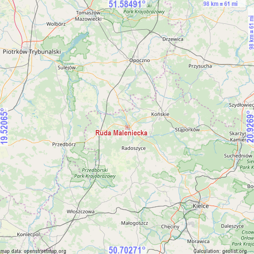
Ruda Maleniecka GPS coordinates[2]
51° 8' 45.312" North, 20° 13' 25.572" East
| Map corner | latitude | longitude |
|---|---|---|
| Upper-left | 51.58491°, | 19.52065° |
| Center: | 51.14592°, | 20.22377° |
| Lower-right: | 50.70271°, | 20.9269° |
| Map W x H: | 98.1×98.1 km | = 61×61mi |
| max Lat: | 54.83135° ⇑50.6% North |
| Ruda Maleniecka: | 51.14592° |
| min Lat: | ⇓49.4% South 49.21328° |
| min Long | Ruda Maleniecka | max Long |
| 14.20249° | 20.22377° | 24.03723° |
| W 61.4%⇐ | ⇒38.6% E |
Elevation
Elevation of Ruda Maleniecka is 217 m = 712 ft, and this is 25.6 m = 84 ft above average elevation for this country.
| Max E: |
974 m = 3196 ft | 33.8% |
| Ruda Maleniecka | 217 m 712 ft | |
| Avg. | 191.4 m = 628 ft | |
Min E: |
-3 m = -10 ft | 66.2% |
See also: Poland elevation on elevation.city.
Geographical zone
Ruda Maleniecka is located in North temperate zone (between Tropic of Cancer and the Arctic Circle). Distance of this North polar circle is 1714.3 km =1065.2 mi to North.| Distance of | km | miles | from Ruda Maleniecka |
|---|---|---|---|
| North Pole | 4320.2 | 2684.4 | to North |
| Arctic Circle | 1714.3 | 1065.2 | to North |
| Tropic Cancer | 3081 | 1914.4 | to South |
| Equator | 5686.9 | 3533.7 | to South |


Nearby cities:
15 places around Ruda Maleniecka: (largest is in red/bold)
• Aleksandrów
21.4 km =13.3 mi,  310°
310°
• Białaczów
17.7 km =11 mi,  16°
16°
• Czermno
14.3 km =8.9 mi,  253°
253°
• Fałków
8.3 km =5.2 mi,  262°
262°
• Gowarczów
21 km =13 mi,  45°
45°
• Końskie
13.7 km =8.5 mi,  68°
68°
• Mniów
23.5 km =14.6 mi,  129°
129°
• Paradyż
19.4 km =12.1 mi,  336°
336°
• Radoszyce
8.4 km =5.2 mi,  163°
163°
• Rogów
16.1 km =10 mi, 66°
• Smyków
16.7 km =10.4 mi, 132°
• Stąporków
24.3 km =15.1 mi,  92°
92°
• Słupia
15.8 km =9.8 mi,  201°
201°
• Łopuszno
22 km =13.7 mi,  175°
175°
• Żarnów
11.6 km =7.2 mi, 342°
Sources, notices
• [Note1] Compared only with cities in Poland existing in our database
• [Src1] Map data: © OpenStreetMap contributors (CC-BY-SA)
• [Src2] Other city data from geonames.org with taken over terms of usage.
• [Src3] Geographical zone / Annual Mean Temperature by Robert A. Rohde @ Wikipedia
