Krzemienica geodata
Krzemienica (Subcarpathian) is a populated place; located in Poland in Europe/Warsaw (GMT+2) time zone. With population of 2,664 people, there are 1182 cities with bigger population in this country. Compared to other cities in Poland, 79.5% of cities are located further ↑North; 87.1% of cities are located further ←West and 67.4% of cities have lower elevation than Krzemienica. Note1


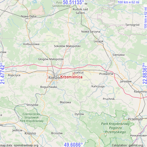
Krzemienica GPS coordinates[2]
50° 3' 43.56" North, 22° 10' 49.944" East
| Map corner | latitude | longitude |
|---|---|---|
| Upper-left | 50.51135°, | 21.47742° |
| Center: | 50.0621°, | 22.18054° |
| Lower-right: | 49.6086°, | 22.88367° |
| Map W x H: | 100.4×100.4 km | = 62.4×62.4mi |
| max Lat: | 54.83135° ⇑79.5% North |
| Krzemienica: | 50.0621° |
| min Lat: | ⇓20.5% South 49.21328° |
| min Long | Krzemienica | max Long |
| 14.20249° | 22.18054° | 24.03723° |
| W 87.1%⇐ | ⇒12.9% E |
Elevation
Elevation of Krzemienica is 221 m = 725 ft, and this is 29.6 m = 97 ft above average elevation for this country.
| Max E: |
974 m = 3196 ft | 32.6% |
| Krzemienica | 221 m 725 ft | |
| Avg. | 191.4 m = 628 ft | |
Min E: |
-3 m = -10 ft | 67.4% |
See also: Poland elevation on elevation.city.
Geographical zone
Krzemienica is located in North temperate zone (between Tropic of Cancer and the Arctic Circle). Distance of this North polar circle is 1834.8 km =1140.1 mi to North.| Distance of | km | miles | from Krzemienica |
|---|---|---|---|
| North Pole | 4440.7 | 2759.3 | to North |
| Arctic Circle | 1834.8 | 1140.1 | to North |
| Tropic Cancer | 2960.5 | 1839.6 | to South |
| Equator | 5566.4 | 3458.8 | to South |


Nearby cities:
15 places around Krzemienica: (largest is in red/bold)
• Albigowa
6.2 km =3.9 mi,  149°
149°
• Białobrzegi
10.9 km =6.8 mi,  65°
65°
• Chmielnik
10.1 km =6.3 mi,  194°
194°
• Czarna
5.3 km =3.3 mi,  0°
0°
• Głuchów
6.8 km =4.2 mi, 71°
• Handzlówka
8 km =5 mi,  157°
157°
• Kosina
10.7 km =6.6 mi,  83°
83°
• Kraczkowa
2.8 km =1.7 mi,  198°
198°
• Krasne
6.8 km =4.2 mi,  264°
264°
• Markowa
11.5 km =7.1 mi,  110°
110°
• Sonina
6.1 km =3.8 mi,  91°
91°
• Trzebownisko
10.4 km =6.5 mi,  279°
279°
• Wysoka
6 km =3.7 mi, 108°
• Wólka Podleśna
7.9 km =4.9 mi,  321°
321°
• Łańcut
3.5 km =2.2 mi, 78°
Sources, notices
• [Note1] Compared only with cities in Poland existing in our database
• [Src1] Map data: © OpenStreetMap contributors (CC-BY-SA)
• [Src2] Other city data from geonames.org with taken over terms of usage.
• [Src3] Geographical zone / Annual Mean Temperature by Robert A. Rohde @ Wikipedia
