Wólka Tanewska geodata
Wólka Tanewska (Subcarpathian) is a populated place; located in Poland in Europe/Warsaw (GMT+2) time zone. With population of 1,453 people, there are 1912 cities with bigger population in this country. Compared to other cities in Poland, 67.3% of cities are located further ↑North; 88.2% of cities are located further ←West and 50.2% of cities have higher elevation than Wólka Tanewska. Note1


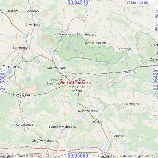
Wólka Tanewska GPS coordinates[2]
50° 30' 0.18" North, 22° 15' 40.068" East
| Map corner | latitude | longitude |
|---|---|---|
| Upper-left | 50.94518°, | 21.55801° |
| Center: | 50.50005°, | 22.26113° |
| Lower-right: | 50.05069°, | 22.96426° |
| Map W x H: | 99.5×99.5 km | = 61.8×61.8mi |
| max Lat: | 54.83135° ⇑67.3% North |
| Wólka Tanewska: | 50.50005° |
| min Lat: | ⇓32.7% South 49.21328° |
| min Long | Wólka Tanewska | max Long |
| 14.20249° | 22.26113° | 24.03723° |
| W 88.2%⇐ | ⇒11.8% E |
Elevation
Elevation of Wólka Tanewska is 171 m = 561 ft, and this is 20.4 m = 67 ft below average elevation for this country.
| Max E: |
974 m = 3196 ft | 50.2% |
| Avg. | 191.4 m = 628 ft | |
| Wólka Tanewska | 171 m = 561 ft | |
Min E: |
-3 m = -10 ft | 49.8% |
See also: Poland elevation on elevation.city.
Geographical zone
Wólka Tanewska is located in North temperate zone (between Tropic of Cancer and the Arctic Circle). Distance of this North polar circle is 1786.1 km =1109.8 mi to North.| Distance of | km | miles | from Wólka Tanewska |
|---|---|---|---|
| North Pole | 4392 | 2729.1 | to North |
| Arctic Circle | 1786.1 | 1109.8 | to North |
| Tropic Cancer | 3009.2 | 1869.8 | to South |
| Equator | 5615.1 | 3489.1 | to South |


Nearby cities:
15 places around Wólka Tanewska: (largest is in red/bold)
• Bieliny
7.1 km =4.4 mi,  154°
154°
• Bystre
16.5 km =10.3 mi,  144°
144°
• Harasiuki
15.2 km =9.4 mi,  100°
100°
• Jarocin
8.3 km =5.2 mi,  30°
30°
• Jeżowe
16.8 km =10.4 mi,  214°
214°
• Kończyce
11.2 km =7 mi,  222°
222°
• Krzeszów
12.1 km =7.5 mi, 151°
• Nisko
8.9 km =5.5 mi,  284°
284°
• Przędzel
3 km =1.9 mi,  258°
258°
• Pysznica
12.1 km =7.5 mi,  309°
309°
• Racławice
6.9 km =4.3 mi, 282°
• Rudnik nad Sanem
6.6 km =4.1 mi,  187°
187°
• Tarnogóra
15.2 km =9.4 mi,  164°
164°
• Ulanów
1.1 km =0.7 mi,  170°
170°
• Zarzecze
5.6 km =3.5 mi,  303°
303°
Sources, notices
• [Note1] Compared only with cities in Poland existing in our database
• [Src1] Map data: © OpenStreetMap contributors (CC-BY-SA)
• [Src2] Other city data from geonames.org with taken over terms of usage.
• [Src3] Geographical zone / Annual Mean Temperature by Robert A. Rohde @ Wikipedia
