Jarocin geodata
Jarocin (Subcarpathian) is a seat of a third-order administrative division; located in Poland in Europe/Warsaw (GMT+2) time zone. With population of 1,300 people, there are 2055 cities with bigger population in this country. Compared to other cities in Poland, 66.1% of cities are located further ↑North; 89.3% of cities are located further ←West and 54.6% of cities have lower elevation than Jarocin. Note1


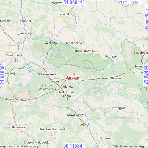
Jarocin GPS coordinates[2]
50° 33' 52.524" North, 22° 19' 16.356" East
| Map corner | latitude | longitude |
|---|---|---|
| Upper-left | 51.00911°, | 21.61809° |
| Center: | 50.56459°, | 22.32121° |
| Lower-right: | 50.11584°, | 23.02434° |
| Map W x H: | 99.3×99.3 km | = 61.7×61.7mi |
| max Lat: | 54.83135° ⇑66.1% North |
| Jarocin: | 50.56459° |
| min Lat: | ⇓33.9% South 49.21328° |
| min Long | Jarocin | max Long |
| 14.20249° | 22.32121° | 24.03723° |
| W 89.3%⇐ | ⇒10.7% E |
Elevation
Elevation of Jarocin is 184 m = 604 ft, and this is 7.4 m = 24 ft below average elevation for this country.
| Max E: |
974 m = 3196 ft | 45.4% |
| Avg. | 191.4 m = 628 ft | |
| Jarocin | 184 m = 604 ft | |
Min E: |
-3 m = -10 ft | 54.6% |
See also: Poland elevation on elevation.city.
Geographical zone
Jarocin is located in North temperate zone (between Tropic of Cancer and the Arctic Circle). Distance of this North polar circle is 1778.9 km =1105.4 mi to North.| Distance of | km | miles | from Jarocin |
|---|---|---|---|
| North Pole | 4384.8 | 2724.6 | to North |
| Arctic Circle | 1778.9 | 1105.4 | to North |
| Tropic Cancer | 3016.3 | 1874.2 | to South |
| Equator | 5622.3 | 3493.5 | to South |


Nearby cities:
15 places around Jarocin: (largest is in red/bold)
• Bieliny
13.6 km =8.5 mi,  184°
184°
• Harasiuki
14.6 km =9.1 mi,  132°
132°
• Janów Lubelski
17 km =10.6 mi,  21°
21°
• Kończyce
19.5 km =12.1 mi,  217°
217°
• Krzeszów
17.9 km =11.1 mi, 175°
• Modliborzyce
21.1 km =13.1 mi,  1°
1°
• Nisko
13.8 km =8.6 mi,  248°
248°
• Przędzel
10.6 km =6.6 mi, 222°
• Pysznica
13.6 km =8.5 mi,  272°
272°
• Racławice
12.4 km =7.7 mi,  242°
242°
• Rudnik nad Sanem
14.6 km =9.1 mi,  200°
200°
• Stalowa Wola
19 km =11.8 mi,  276°
276°
• Ulanów
9.2 km =5.7 mi,  206°
206°
• Wólka Tanewska
8.3 km =5.2 mi, 210°
• Zarzecze
9.8 km =6.1 mi, 245°
Sources, notices
• [Note1] Compared only with cities in Poland existing in our database
• [Src1] Map data: © OpenStreetMap contributors (CC-BY-SA)
• [Src2] Other city data from geonames.org with taken over terms of usage.
• [Src3] Geographical zone / Annual Mean Temperature by Robert A. Rohde @ Wikipedia
