Ulanów geodata
Ulanów (Subcarpathian) is a seat of a third-order administrative division; located in Poland in Europe/Warsaw (GMT+2) time zone. With population of 1,520 people, there are 1827 cities with bigger population in this country. Compared to other cities in Poland, 67.5% of cities are located further ↑North; 88.2% of cities are located further ←West and 52.9% of cities have higher elevation than Ulanów. Note1


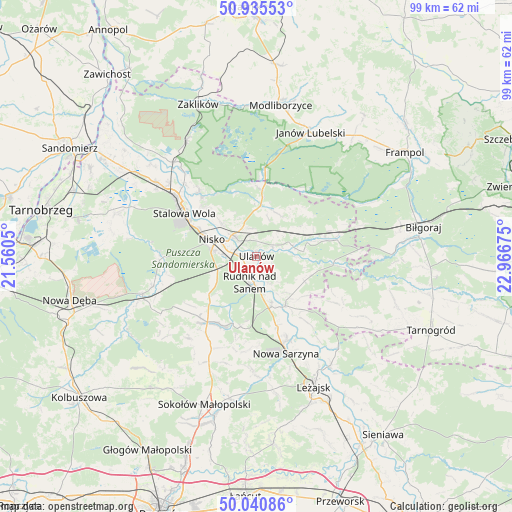
Ulanów GPS coordinates[2]
50° 29' 25.116" North, 22° 15' 49.032" East
| Map corner | latitude | longitude |
|---|---|---|
| Upper-left | 50.93553°, | 21.5605° |
| Center: | 50.49031°, | 22.26362° |
| Lower-right: | 50.04086°, | 22.96675° |
| Map W x H: | 99.5×99.5 km | = 61.8×61.8mi |
| max Lat: | 54.83135° ⇑67.5% North |
| Ulanów: | 50.49031° |
| min Lat: | ⇓32.5% South 49.21328° |
| min Long | Ulanów | max Long |
| 14.20249° | 22.26362° | 24.03723° |
| W 88.2%⇐ | ⇒11.8% E |
Elevation
Elevation of Ulanów is 164 m = 538 ft, and this is 27.4 m = 90 ft below average elevation for this country.
| Max E: |
974 m = 3196 ft | 52.9% |
| Avg. | 191.4 m = 628 ft | |
| Ulanów | 164 m = 538 ft | |
Min E: |
-3 m = -10 ft | 47.1% |
See also: Poland elevation on elevation.city.
Geographical zone
Ulanów is located in North temperate zone (between Tropic of Cancer and the Arctic Circle). Distance of this North polar circle is 1787.2 km =1110.5 mi to North.| Distance of | km | miles | from Ulanów |
|---|---|---|---|
| North Pole | 4393.1 | 2729.7 | to North |
| Arctic Circle | 1787.2 | 1110.5 | to North |
| Tropic Cancer | 3008.1 | 1869.1 | to South |
| Equator | 5614 | 3488.4 | to South |


Nearby cities:
15 places around Ulanów: (largest is in red/bold)
• Bieliny
6.1 km =3.8 mi,  151°
151°
• Bystre
15.5 km =9.6 mi,  142°
142°
• Harasiuki
14.9 km =9.3 mi,  96°
96°
• Jarocin
9.2 km =5.7 mi,  26°
26°
• Jeżowe
16.1 km =10 mi,  216°
216°
• Kończyce
10.6 km =6.6 mi,  227°
227°
• Krzeszów
11.1 km =6.9 mi, 149°
• Nisko
9.4 km =5.8 mi,  290°
290°
• Przędzel
3.2 km =2 mi,  278°
278°
• Pysznica
13 km =8.1 mi,  312°
312°
• Racławice
7.4 km =4.6 mi, 290°
• Rudnik nad Sanem
5.5 km =3.4 mi,  191°
191°
• Tarnogóra
14.1 km =8.8 mi,  164°
164°
• Wólka Tanewska
1.1 km =0.7 mi,  350°
350°
• Zarzecze
6.4 km =4 mi, 310°
Sources, notices
• [Note1] Compared only with cities in Poland existing in our database
• [Src1] Map data: © OpenStreetMap contributors (CC-BY-SA)
• [Src2] Other city data from geonames.org with taken over terms of usage.
• [Src3] Geographical zone / Annual Mean Temperature by Robert A. Rohde @ Wikipedia
