Nisko geodata
Nisko (Subcarpathian) is a seat of a second-order administrative division; located in Poland in Europe/Warsaw (GMT+2) time zone. With population of 15,573 people, there are 320 cities with bigger population in this country. Compared to other cities in Poland, 67% of cities are located further ↑North; 86.7% of cities are located further ←West and 53.7% of cities have higher elevation than Nisko. Note1


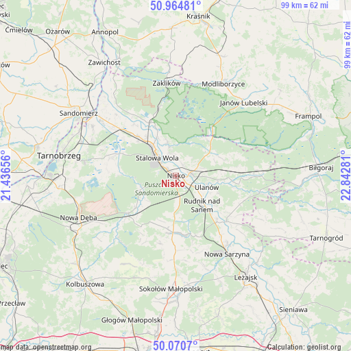
Nisko GPS coordinates[2]
50° 31' 11.532" North, 22° 8' 22.848" East
| Map corner | latitude | longitude |
|---|---|---|
| Upper-left | 50.96481°, | 21.43656° |
| Center: | 50.51987°, | 22.13968° |
| Lower-right: | 50.0707°, | 22.84281° |
| Map W x H: | 99.4×99.4 km | = 61.8×61.8mi |
| max Lat: | 54.83135° ⇑67% North |
| Nisko: | 50.51987° |
| min Lat: | ⇓33% South 49.21328° |
| min Long | Nisko | max Long |
| 14.20249° | 22.13968° | 24.03723° |
| W 86.7%⇐ | ⇒13.3% E |
Elevation
Elevation of Nisko is 162 m = 531 ft, and this is 29.4 m = 96 ft below average elevation for this country.
| Max E: |
974 m = 3196 ft | 53.7% |
| Avg. | 191.4 m = 628 ft | |
| Nisko | 162 m = 531 ft | |
Min E: |
-3 m = -10 ft | 46.3% |
See also: Poland elevation on elevation.city.
Geographical zone
Nisko is located in North temperate zone (between Tropic of Cancer and the Arctic Circle). Distance of this North polar circle is 1783.9 km =1108.5 mi to North.| Distance of | km | miles | from Nisko |
|---|---|---|---|
| North Pole | 4389.8 | 2727.7 | to North |
| Arctic Circle | 1783.9 | 1108.5 | to North |
| Tropic Cancer | 3011.4 | 1871.2 | to South |
| Equator | 5617.3 | 3490.4 | to South |


Nearby cities:
15 places around Nisko: (largest is in red/bold)
• Bieliny
14.5 km =9 mi,  126°
126°
• Bojanów
17 km =10.6 mi,  231°
231°
• Gwoździec
19.2 km =11.9 mi,  213°
213°
• Jarocin
13.8 km =8.6 mi,  68°
68°
• Jeżowe
16.1 km =10 mi,  183°
183°
• Kończyce
10.5 km =6.5 mi,  174°
174°
• Krzeszów
19.3 km =12 mi, 131°
• Przędzel
6.3 km =3.9 mi,  116°
116°
• Pysznica
5.6 km =3.5 mi,  352°
352°
• Racławice
2 km =1.2 mi,  110°
110°
• Rudnik nad Sanem
11.6 km =7.2 mi,  138°
138°
• Stalowa Wola
9.3 km =5.8 mi,  318°
318°
• Ulanów
9.4 km =5.8 mi, 110°
• Wólka Tanewska
8.9 km =5.5 mi,  104°
104°
• Zarzecze
4 km =2.5 mi,  77°
77°
Sources, notices
• [Note1] Compared only with cities in Poland existing in our database
• [Src1] Map data: © OpenStreetMap contributors (CC-BY-SA)
• [Src2] Other city data from geonames.org with taken over terms of usage.
• [Src3] Geographical zone / Annual Mean Temperature by Robert A. Rohde @ Wikipedia
