Przędzel geodata
Przędzel (Subcarpathian) is a populated place; located in Poland in Europe/Warsaw (GMT+2) time zone. With population of 1,823 people, there are 1596 cities with bigger population in this country. Compared to other cities in Poland, 67.4% of cities are located further ↑North; 87.6% of cities are located further ←West and 54.5% of cities have higher elevation than Przędzel. Note1
Administrative division(s):
- Level 1: Subcarpathian
- Level 2: Powiat niżański
- Level 3: Rudnik nad Sanem


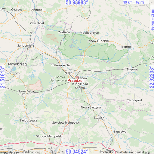
Przędzel GPS coordinates[2]
50° 29' 40.74" North, 22° 13' 9.3" East
| Map corner | latitude | longitude |
|---|---|---|
| Upper-left | 50.93983°, | 21.51613° |
| Center: | 50.49465°, | 22.21925° |
| Lower-right: | 50.04524°, | 22.92238° |
| Map W x H: | 99.5×99.5 km | = 61.8×61.8mi |
| max Lat: | 54.83135° ⇑67.4% North |
| Przędzel: | 50.49465° |
| min Lat: | ⇓32.6% South 49.21328° |
| min Long | Przędzel | max Long |
| 14.20249° | 22.21925° | 24.03723° |
| W 87.6%⇐ | ⇒12.4% E |
Elevation
Elevation of Przędzel is 160 m = 525 ft, and this is 31.4 m = 103 ft below average elevation for this country.
| Max E: |
974 m = 3196 ft | 54.5% |
| Avg. | 191.4 m = 628 ft | |
| Przędzel | 160 m = 525 ft | |
Min E: |
-3 m = -10 ft | 45.5% |
See also: Poland elevation on elevation.city.
Geographical zone
Przędzel is located in North temperate zone (between Tropic of Cancer and the Arctic Circle). Distance of this North polar circle is 1786.7 km =1110.2 mi to North.| Distance of | km | miles | from Przędzel |
|---|---|---|---|
| North Pole | 4392.6 | 2729.4 | to North |
| Arctic Circle | 1786.7 | 1110.2 | to North |
| Tropic Cancer | 3008.6 | 1869.5 | to South |
| Equator | 5614.5 | 3488.7 | to South |


Nearby cities:
15 places around Przędzel: (largest is in red/bold)
• Bieliny
8.4 km =5.2 mi,  133°
133°
• Bystre
18 km =11.2 mi,  135°
135°
• Jarocin
10.6 km =6.6 mi,  42°
42°
• Jeżowe
14.8 km =9.2 mi,  206°
206°
• Kończyce
9 km =5.6 mi, 211°
• Krzeszów
13.3 km =8.3 mi, 139°
• Nisko
6.3 km =3.9 mi,  296°
296°
• Pysznica
10.5 km =6.5 mi,  322°
322°
• Racławice
4.4 km =2.7 mi, 299°
• Rudnik nad Sanem
6.3 km =3.9 mi,  160°
160°
• Stalowa Wola
15.3 km =9.5 mi,  309°
309°
• Tarnogóra
15.7 km =9.8 mi,  153°
153°
• Ulanów
3.2 km =2 mi,  98°
98°
• Wólka Tanewska
3 km =1.9 mi,  78°
78°
• Zarzecze
4 km =2.5 mi,  335°
335°
Sources, notices
• [Note1] Compared only with cities in Poland existing in our database
• [Src1] Map data: © OpenStreetMap contributors (CC-BY-SA)
• [Src2] Other city data from geonames.org with taken over terms of usage.
• [Src3] Geographical zone / Annual Mean Temperature by Robert A. Rohde @ Wikipedia
