Grajewo geodata
Grajewo (Podlasie) is a seat of a second-order administrative division; located in Poland in Europe/Warsaw (GMT+2) time zone. With population of 22,803 people, there are 214 cities with bigger population in this country. Compared to other cities in Poland, 90.9% of cities are located further ↓South; 91.1% of cities are located further ←West and 68.2% of cities have higher elevation than Grajewo. Note1


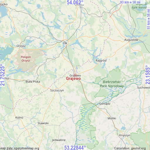
Grajewo GPS coordinates[2]
53° 38' 50.208" North, 22° 27' 19.332" East
| Map corner | latitude | longitude |
|---|---|---|
| Upper-left | 54.062°, | 21.75225° |
| Center: | 53.64728°, | 22.45537° |
| Lower-right: | 53.22844°, | 23.1585° |
| Map W x H: | 92.7×92.7 km | = 57.6×57.6mi |
| max Lat: | 54.83135° ⇑9.1% North |
| Grajewo: | 53.64728° |
| min Lat: | ⇓90.9% South 49.21328° |
| min Long | Grajewo | max Long |
| 14.20249° | 22.45537° | 24.03723° |
| W 91.1%⇐ | ⇒8.9% E |
Elevation
Elevation of Grajewo is 125 m = 410 ft, and this is 66.4 m = 218 ft below average elevation for this country.
| Max E: |
974 m = 3196 ft | 68.2% |
| Avg. | 191.4 m = 628 ft | |
| Grajewo | 125 m = 410 ft | |
Min E: |
-3 m = -10 ft | 31.8% |
See also: Poland elevation on elevation.city.
Geographical zone
Grajewo is located in North temperate zone (between Tropic of Cancer and the Arctic Circle). Distance of this North polar circle is 1436.2 km =892.4 mi to North.| Distance of | km | miles | from Grajewo |
|---|---|---|---|
| North Pole | 4042 | 2511.6 | to North |
| Arctic Circle | 1436.2 | 892.4 | to North |
| Tropic Cancer | 3359.1 | 2087.2 | to South |
| Equator | 5965 | 3706.5 | to South |


Nearby cities:
15 places around Grajewo: (largest is in red/bold)
• Bargłów Kościelny
28 km =17.4 mi,  59°
59°
• Biała Piska
26.2 km =16.3 mi,  261°
261°
• Ełk
21 km =13 mi,  343°
343°
• Goniadz
25.5 km =15.8 mi,  133°
133°
• Grabowo
28.3 km =17.6 mi,  224°
224°
• Kalinowo
29 km =18 mi,  29°
29°
• Mońki
35.2 km =21.9 mi,  139°
139°
• Prostki
6 km =3.7 mi, 344°
• Radziłów
26.6 km =16.5 mi,  186°
186°
• Rajgród
18.9 km =11.7 mi, 60°
• Stare Juchy
35.7 km =22.2 mi,  328°
328°
• Stawiski
35.8 km =22.2 mi,  213°
213°
• Szczuczyn
14.6 km =9.1 mi,  230°
230°
• Trzcianne
36.8 km =22.9 mi,  155°
155°
• Wąsosz
16.6 km =10.3 mi, 212°
Sources, notices
• [Note1] Compared only with cities in Poland existing in our database
• [Src1] Map data: © OpenStreetMap contributors (CC-BY-SA)
• [Src2] Other city data from geonames.org with taken over terms of usage.
• [Src3] Geographical zone / Annual Mean Temperature by Robert A. Rohde @ Wikipedia
