Szczuczyn geodata
Szczuczyn (Podlasie) is a seat of a third-order administrative division; located in Poland in Europe/Warsaw (GMT+2) time zone. With population of 3,552 people, there are 902 cities with bigger population in this country. Compared to other cities in Poland, 90.3% of cities are located further ↓South; 88.5% of cities are located further ←West and 67.1% of cities have higher elevation than Szczuczyn. Note1


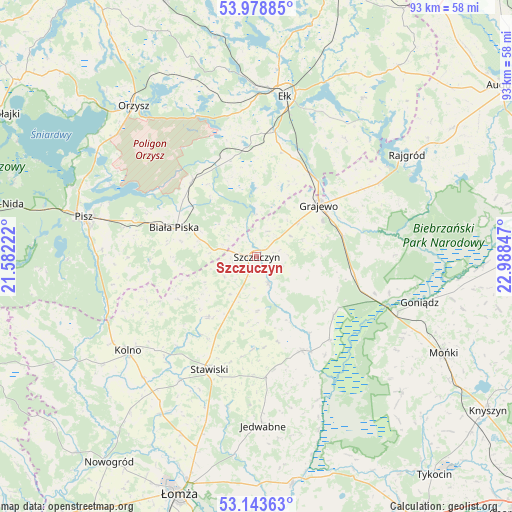
Szczuczyn GPS coordinates[2]
53° 33' 47.88" North, 22° 17' 7.224" East
| Map corner | latitude | longitude |
|---|---|---|
| Upper-left | 53.97885°, | 21.58222° |
| Center: | 53.5633°, | 22.28534° |
| Lower-right: | 53.14363°, | 22.98847° |
| Map W x H: | 92.9×92.9 km | = 57.7×57.7mi |
| max Lat: | 54.83135° ⇑9.7% North |
| Szczuczyn: | 53.5633° |
| min Lat: | ⇓90.3% South 49.21328° |
| min Long | Szczuczyn | max Long |
| 14.20249° | 22.28534° | 24.03723° |
| W 88.5%⇐ | ⇒11.5% E |
Elevation
Elevation of Szczuczyn is 128 m = 420 ft, and this is 63.4 m = 208 ft below average elevation for this country.
| Max E: |
974 m = 3196 ft | 67.1% |
| Avg. | 191.4 m = 628 ft | |
| Szczuczyn | 128 m = 420 ft | |
Min E: |
-3 m = -10 ft | 32.9% |
See also: Poland elevation on elevation.city.
Geographical zone
Szczuczyn is located in North temperate zone (between Tropic of Cancer and the Arctic Circle). Distance of this North polar circle is 1445.5 km =898.2 mi to North.| Distance of | km | miles | from Szczuczyn |
|---|---|---|---|
| North Pole | 4051.4 | 2517.4 | to North |
| Arctic Circle | 1445.5 | 898.2 | to North |
| Tropic Cancer | 3349.8 | 2081.5 | to South |
| Equator | 5955.7 | 3700.7 | to South |


Nearby cities:
15 places around Szczuczyn: (largest is in red/bold)
• Biała Piska
15.6 km =9.7 mi,  290°
290°
• Ełk
29.9 km =18.6 mi,  10°
10°
• Goniadz
30.9 km =19.2 mi,  105°
105°
• Grabowo
13.9 km =8.6 mi,  218°
218°
• Grajewo
14.6 km =9.1 mi,  50°
50°
• Janowo
33.8 km =21 mi,  226°
226°
• Jedwabne
30.9 km =19.2 mi,  177°
177°
• Kolno
29 km =18 mi, 234°
• Mały Płock
33.5 km =20.8 mi,  210°
210°
• Pisz
32 km =19.9 mi,  282°
282°
• Prostki
17.9 km =11.1 mi,  32°
32°
• Radziłów
18.9 km =11.7 mi,  154°
154°
• Rajgród
33.4 km =20.8 mi,  56°
56°
• Stawiski
22.2 km =13.8 mi,  202°
202°
• Wąsosz
5.1 km =3.2 mi, 154°
Sources, notices
• [Note1] Compared only with cities in Poland existing in our database
• [Src1] Map data: © OpenStreetMap contributors (CC-BY-SA)
• [Src2] Other city data from geonames.org with taken over terms of usage.
• [Src3] Geographical zone / Annual Mean Temperature by Robert A. Rohde @ Wikipedia
