Fałków geodata
Fałków (Świętokrzyskie) is a seat of a third-order administrative division; located in Poland in Europe/Warsaw (GMT+2) time zone. With population of 1,100 people, there are 2307 cities with bigger population in this country. Compared to other cities in Poland, 51.3% of cities are located further ↑North; 60.1% of cities are located further ←West and 69.8% of cities have lower elevation than Fałków. Note1


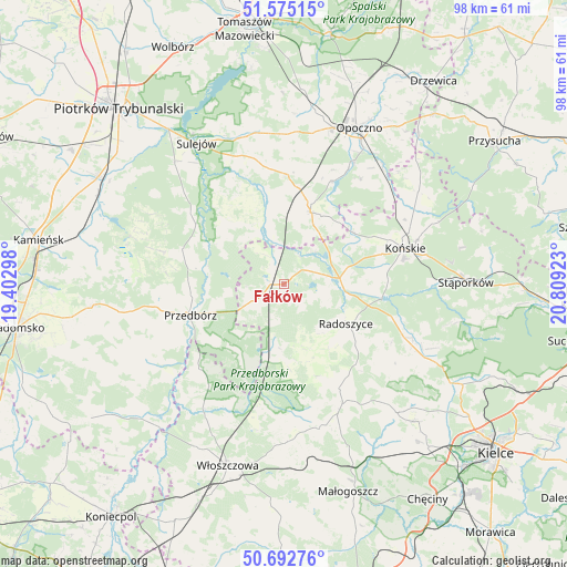
Fałków GPS coordinates[2]
51° 8' 9.816" North, 20° 6' 21.96" East
| Map corner | latitude | longitude |
|---|---|---|
| Upper-left | 51.57515°, | 19.40298° |
| Center: | 51.13606°, | 20.1061° |
| Lower-right: | 50.69276°, | 20.80923° |
| Map W x H: | 98.1×98.1 km | = 61×61mi |
| max Lat: | 54.83135° ⇑51.3% North |
| Fałków: | 51.13606° |
| min Lat: | ⇓48.7% South 49.21328° |
| min Long | Fałków | max Long |
| 14.20249° | 20.1061° | 24.03723° |
| W 60.1%⇐ | ⇒39.9% E |
Elevation
Elevation of Fałków is 229 m = 751 ft, and this is 37.6 m = 123 ft above average elevation for this country.
| Max E: |
974 m = 3196 ft | 30.2% |
| Fałków | 229 m 751 ft | |
| Avg. | 191.4 m = 628 ft | |
Min E: |
-3 m = -10 ft | 69.8% |
See also: Poland elevation on elevation.city.
Geographical zone
Fałków is located in North temperate zone (between Tropic of Cancer and the Arctic Circle). Distance of this North polar circle is 1715.4 km =1065.9 mi to North.| Distance of | km | miles | from Fałków |
|---|---|---|---|
| North Pole | 4321.3 | 2685.1 | to North |
| Arctic Circle | 1715.4 | 1065.9 | to North |
| Tropic Cancer | 3079.9 | 1913.8 | to South |
| Equator | 5685.8 | 3533 | to South |


Nearby cities:
15 places around Fałków: (largest is in red/bold)
• Aleksandrów
17.1 km =10.6 mi,  331°
331°
• Białaczów
22.4 km =13.9 mi,  36°
36°
• Czermno
6.2 km =3.9 mi,  242°
242°
• Końskie
21.8 km =13.5 mi,  73°
73°
• Paradyż
18.9 km =11.7 mi,  1°
1°
• Przedbórz
17.1 km =10.6 mi,  251°
251°
• Radoszyce
12.7 km =7.9 mi,  123°
123°
• Rogów
24.1 km =15 mi, 71°
• Ruda Maleniecka
8.3 km =5.2 mi,  82°
82°
• Ręczno
18.6 km =11.6 mi,  288°
288°
• Smyków
22.9 km =14.2 mi, 116°
• Słupia
13.8 km =8.6 mi,  169°
169°
• Łopuszno
23.2 km =14.4 mi,  154°
154°
• Łęki Szlacheckie
22.2 km =13.8 mi,  284°
284°
• Żarnów
13.1 km =8.1 mi,  21°
21°
Sources, notices
• [Note1] Compared only with cities in Poland existing in our database
• [Src1] Map data: © OpenStreetMap contributors (CC-BY-SA)
• [Src2] Other city data from geonames.org with taken over terms of usage.
• [Src3] Geographical zone / Annual Mean Temperature by Robert A. Rohde @ Wikipedia
