Krasne geodata
Krasne (Mazovia) is a seat of a third-order administrative division; located in Poland in Europe/Warsaw (GMT+2) time zone. With population of 1,000 people, there are 2459 cities with bigger population in this country. Compared to other cities in Poland, 82.7% of cities are located further ↓South; 72.1% of cities are located further ←West and 74% of cities have higher elevation than Krasne. Note1


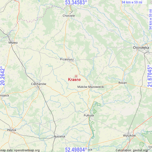
Krasne GPS coordinates[2]
52° 55' 26.436" North, 20° 58' 2.352" East
| Map corner | latitude | longitude |
|---|---|---|
| Upper-left | 53.34583°, | 20.2642° |
| Center: | 52.92401°, | 20.96732° |
| Lower-right: | 52.49804°, | 21.67045° |
| Map W x H: | 94.3×94.3 km | = 58.6×58.6mi |
| max Lat: | 54.83135° ⇑17.3% North |
| Krasne: | 52.92401° |
| min Lat: | ⇓82.7% South 49.21328° |
| min Long | Krasne | max Long |
| 14.20249° | 20.96732° | 24.03723° |
| W 72.1%⇐ | ⇒27.9% E |
Elevation
Elevation of Krasne is 113 m = 371 ft, and this is 78.4 m = 257 ft below average elevation for this country.
| Max E: |
974 m = 3196 ft | 74% |
| Avg. | 191.4 m = 628 ft | |
| Krasne | 113 m = 371 ft | |
Min E: |
-3 m = -10 ft | 26% |
See also: Poland elevation on elevation.city.
Geographical zone
Krasne is located in North temperate zone (between Tropic of Cancer and the Arctic Circle). Distance of this North polar circle is 1516.6 km =942.4 mi to North.| Distance of | km | miles | from Krasne |
|---|---|---|---|
| North Pole | 4122.5 | 2561.6 | to North |
| Arctic Circle | 1516.6 | 942.4 | to North |
| Tropic Cancer | 3278.7 | 2037.3 | to South |
| Equator | 5884.6 | 3656.5 | to South |


Nearby cities:
15 places around Krasne: (largest is in red/bold)
• Ciechanów
23.8 km =14.8 mi,  258°
258°
• Czernice Borowe
20.5 km =12.7 mi,  305°
305°
• Czerwonka
17 km =10.6 mi,  101°
101°
• Gołotczyzna
23.9 km =14.9 mi,  231°
231°
• Gołymin-Ośrodek
14.4 km =8.9 mi,  206°
206°
• Gzy
20.5 km =12.7 mi,  184°
184°
• Karniewo
9.8 km =6.1 mi,  171°
171°
• Krasnosielc
17.6 km =10.9 mi,  46°
46°
• Maków Mazowiecki
11.1 km =6.9 mi,  126°
126°
• Opinogóra Górna
16.9 km =10.5 mi, 263°
• Przasnysz
12.1 km =7.5 mi,  331°
331°
• Płoniawy-Bramura
9.2 km =5.7 mi, 49°
• Sońsk
24 km =14.9 mi, 228°
• Sypniewo
24.5 km =15.2 mi,  68°
68°
• Szelków
19.5 km =12.1 mi,  120°
120°
Sources, notices
• [Note1] Compared only with cities in Poland existing in our database
• [Src1] Map data: © OpenStreetMap contributors (CC-BY-SA)
• [Src2] Other city data from geonames.org with taken over terms of usage.
• [Src3] Geographical zone / Annual Mean Temperature by Robert A. Rohde @ Wikipedia
