Tarnowiec geodata
Tarnowiec (Subcarpathian) is a seat of a third-order administrative division; located in Poland in Europe/Warsaw (GMT+2) time zone. With population of 1,200 people, there are 2164 cities with bigger population in this country. Compared to other cities in Poland, 93.5% of cities are located further ↑North; 79.9% of cities are located further ←West and 80.9% of cities have lower elevation than Tarnowiec. Note1


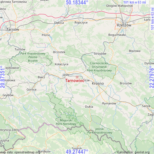
Tarnowiec GPS coordinates[2]
49° 43' 51.888" North, 21° 34' 35.868" East
| Map corner | latitude | longitude |
|---|---|---|
| Upper-left | 50.18344°, | 20.87351° |
| Center: | 49.73108°, | 21.57663° |
| Lower-right: | 49.27447°, | 22.27976° |
| Map W x H: | 101.1×101.1 km | = 62.8×62.8mi |
| max Lat: | 54.83135° ⇑93.5% North |
| Tarnowiec: | 49.73108° |
| min Lat: | ⇓6.5% South 49.21328° |
| min Long | Tarnowiec | max Long |
| 14.20249° | 21.57663° | 24.03723° |
| W 79.9%⇐ | ⇒20.1% E |
Elevation
Elevation of Tarnowiec is 269 m = 883 ft, and this is 77.6 m = 255 ft above average elevation for this country.
| Max E: |
974 m = 3196 ft | 19.1% |
| Tarnowiec | 269 m 883 ft | |
| Avg. | 191.4 m = 628 ft | |
Min E: |
-3 m = -10 ft | 80.9% |
See also: Poland elevation on elevation.city.
Geographical zone
Tarnowiec is located in North temperate zone (between Tropic of Cancer and the Arctic Circle). Distance of this North polar circle is 1871.6 km =1163 mi to North.| Distance of | km | miles | from Tarnowiec |
|---|---|---|---|
| North Pole | 4477.5 | 2782.2 | to North |
| Arctic Circle | 1871.6 | 1163 | to North |
| Tropic Cancer | 2923.7 | 1816.7 | to South |
| Equator | 5529.6 | 3435.9 | to South |


Nearby cities:
15 places around Tarnowiec: (largest is in red/bold)
• Chorkówka
11.6 km =7.2 mi,  143°
143°
• Dębowiec
9.9 km =6.2 mi,  237°
237°
• Frysztak
12.5 km =7.8 mi,  10°
10°
• Jasło
7.6 km =4.7 mi,  281°
281°
• Jedlicze
5.4 km =3.4 mi,  106°
106°
• Kołaczyce
13.3 km =8.3 mi,  309°
309°
• Krosno
14.7 km =9.1 mi, 108°
• Nowy Żmigród
14.7 km =9.1 mi,  195°
195°
• Odrzykoń
11.8 km =7.3 mi,  84°
84°
• Osiek Jasielski
12.2 km =7.6 mi,  211°
211°
• Trzcinica
11.5 km =7.1 mi, 276°
• Wojaszówka
8.5 km =5.3 mi,  52°
52°
• Wróblowa
14.3 km =8.9 mi,  297°
297°
• Zarzecze
9.1 km =5.7 mi,  228°
228°
• Łęki
10.6 km =6.6 mi,  34°
34°
Sources, notices
• [Note1] Compared only with cities in Poland existing in our database
• [Src1] Map data: © OpenStreetMap contributors (CC-BY-SA)
• [Src2] Other city data from geonames.org with taken over terms of usage.
• [Src3] Geographical zone / Annual Mean Temperature by Robert A. Rohde @ Wikipedia
