Białowieża geodata
Białowieża (Podlasie) is a seat of a third-order administrative division; located in Poland in Europe/Warsaw (GMT+2) time zone. With population of 2,670 people, there are 1180 cities with bigger population in this country. Compared to other cities in Poland, 79.3% of cities are located further ↓South; 99.8% of cities are located further ←West and 55.3% of cities have higher elevation than Białowieża. Note1


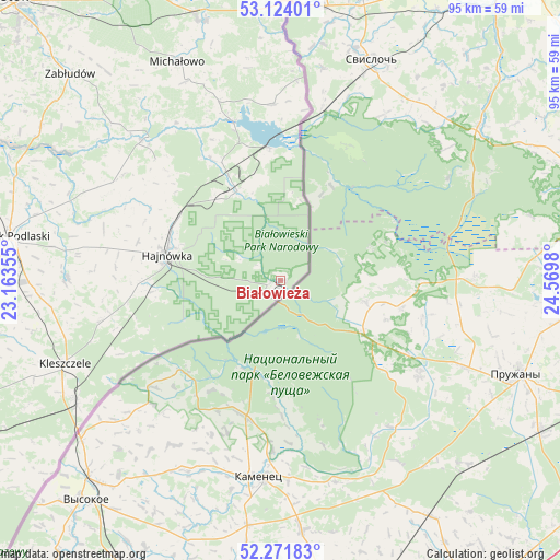
Białowieża GPS coordinates[2]
52° 42' 0" North, 23° 52' 0.012" East
| Map corner | latitude | longitude |
|---|---|---|
| Upper-left | 53.12401°, | 23.16355° |
| Center: | 52.7°, | 23.86667° |
| Lower-right: | 52.27183°, | 24.5698° |
| Map W x H: | 94.8×94.8 km | = 58.9×58.9mi |
| max Lat: | 54.83135° ⇑20.7% North |
| Białowieża: | 52.7° |
| min Lat: | ⇓79.3% South 49.21328° |
| min Long | Białowieża | max Long |
| 14.20249° | 23.86667° | 24.03723° |
| W 99.8%⇐ | ⇒0.2% E |
Elevation
Elevation of Białowieża is 158 m = 518 ft, and this is 33.4 m = 110 ft below average elevation for this country.
| Max E: |
974 m = 3196 ft | 55.3% |
| Avg. | 191.4 m = 628 ft | |
| Białowieża | 158 m = 518 ft | |
Min E: |
-3 m = -10 ft | 44.7% |
See also: Poland elevation on elevation.city.
Geographical zone
Białowieża is located in North temperate zone (between Tropic of Cancer and the Arctic Circle). Distance of this North polar circle is 1541.5 km =957.8 mi to North.| Distance of | km | miles | from Białowieża |
|---|---|---|---|
| North Pole | 4147.4 | 2577.1 | to North |
| Arctic Circle | 1541.5 | 957.8 | to North |
| Tropic Cancer | 3253.8 | 2021.8 | to South |
| Equator | 5859.7 | 3641 | to South |


Nearby cities:
15 places around Białowieża: (largest is in red/bold)
• Bielsk Podlaski
46.4 km =28.8 mi,  278°
278°
• Boćki
55.7 km =34.6 mi,  264°
264°
• Czeremcha
40.4 km =25.1 mi,  239°
239°
• Czyże
30.9 km =19.2 mi, 284°
• Grudki
45.9 km =28.5 mi,  343°
343°
• Hajnówka
19.8 km =12.3 mi, 284°
• Kleszczele
39.2 km =24.4 mi,  248°
248°
• Michałowo
41 km =25.5 mi, 335°
• Milejczyce
53.5 km =33.2 mi, 247°
• Narew
33.3 km =20.7 mi,  315°
315°
• Narewka
16.4 km =10.2 mi,  334°
334°
• Nurzec-Stacja
59 km =36.7 mi, 243°
• Orla
36 km =22.4 mi,  270°
270°
• Wyszki
61.6 km =38.3 mi, 284°
• Zabłudów
49.8 km =30.9 mi,  314°
314°
Sources, notices
• [Note1] Compared only with cities in Poland existing in our database
• [Src1] Map data: © OpenStreetMap contributors (CC-BY-SA)
• [Src2] Other city data from geonames.org with taken over terms of usage.
• [Src3] Geographical zone / Annual Mean Temperature by Robert A. Rohde @ Wikipedia
