Narewka geodata
Narewka (Podlasie) is a populated place; located in Poland in Europe/Warsaw (GMT+2) time zone. With population of 780 people, there are 2898 cities with bigger population in this country. Compared to other cities in Poland, 81.2% of cities are located further ↓South; 99.6% of cities are located further ←West and 59.5% of cities have higher elevation than Narewka. Note1


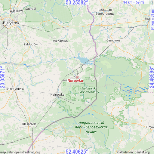
Narewka GPS coordinates[2]
52° 49' 59.196" North, 23° 45' 46.188" East
| Map corner | latitude | longitude |
|---|---|---|
| Upper-left | 53.25582°, | 23.05971° |
| Center: | 52.83311°, | 23.76283° |
| Lower-right: | 52.40625°, | 24.46596° |
| Map W x H: | 94.5×94.5 km | = 58.7×58.7mi |
| max Lat: | 54.83135° ⇑18.8% North |
| Narewka: | 52.83311° |
| min Lat: | ⇓81.2% South 49.21328° |
| min Long | Narewka | max Long |
| 14.20249° | 23.76283° | 24.03723° |
| W 99.6%⇐ | ⇒0.40000000000001% E |
Elevation
Elevation of Narewka is 148 m = 486 ft, and this is 43.4 m = 142 ft below average elevation for this country.
| Max E: |
974 m = 3196 ft | 59.5% |
| Avg. | 191.4 m = 628 ft | |
| Narewka | 148 m = 486 ft | |
Min E: |
-3 m = -10 ft | 40.5% |
See also: Poland elevation on elevation.city.
Geographical zone
Narewka is located in North temperate zone (between Tropic of Cancer and the Arctic Circle). Distance of this North polar circle is 1526.7 km =948.6 mi to North.| Distance of | km | miles | from Narewka |
|---|---|---|---|
| North Pole | 4132.6 | 2567.9 | to North |
| Arctic Circle | 1526.7 | 948.6 | to North |
| Tropic Cancer | 3268.6 | 2031 | to South |
| Equator | 5874.5 | 3650.2 | to South |


Nearby cities:
15 places around Narewka: (largest is in red/bold)
• Białowieża
16.4 km =10.2 mi,  154°
154°
• Białystok
52.1 km =32.4 mi,  309°
309°
• Bielsk Podlaski
39.5 km =24.5 mi,  258°
258°
• Czeremcha
44.9 km =27.9 mi,  218°
218°
• Czyże
23.8 km =14.8 mi,  253°
253°
• Grudki
29.8 km =18.5 mi,  347°
347°
• Hajnówka
15.8 km =9.8 mi,  230°
230°
• Kleszczele
41.3 km =25.7 mi, 225°
• Krynki
48 km =29.8 mi,  0°
0°
• Michałowo
24.7 km =15.3 mi,  335°
335°
• Narew
18.6 km =11.6 mi,  298°
298°
• Orla
32.3 km =20.1 mi,  243°
243°
• Supraśl
50.1 km =31.1 mi,  325°
325°
• Turośń Kościelna
51.5 km =32 mi,  293°
293°
• Zabłudów
34.9 km =21.7 mi, 305°
Sources, notices
• [Note1] Compared only with cities in Poland existing in our database
• [Src1] Map data: © OpenStreetMap contributors (CC-BY-SA)
• [Src2] Other city data from geonames.org with taken over terms of usage.
• [Src3] Geographical zone / Annual Mean Temperature by Robert A. Rohde @ Wikipedia
