Jeżowe geodata
Jeżowe (Subcarpathian) is a seat of a third-order administrative division; located in Poland in Europe/Warsaw (GMT+2) time zone. With population of 5,358 people, there are 652 cities with bigger population in this country. Compared to other cities in Poland, 70.2% of cities are located further ↑North; 86.5% of cities are located further ←West and 51.2% of cities have lower elevation than Jeżowe. Note1


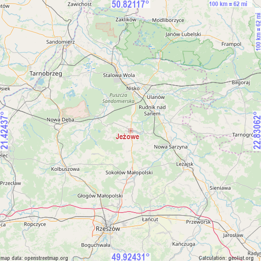
Jeżowe GPS coordinates[2]
50° 22' 29.496" North, 22° 7' 38.964" East
| Map corner | latitude | longitude |
|---|---|---|
| Upper-left | 50.82117°, | 21.42437° |
| Center: | 50.37486°, | 22.12749° |
| Lower-right: | 49.92431°, | 22.83062° |
| Map W x H: | 99.7×99.7 km | = 62×62mi |
| max Lat: | 54.83135° ⇑70.2% North |
| Jeżowe: | 50.37486° |
| min Lat: | ⇓29.8% South 49.21328° |
| min Long | Jeżowe | max Long |
| 14.20249° | 22.12749° | 24.03723° |
| W 86.5%⇐ | ⇒13.5% E |
Elevation
Elevation of Jeżowe is 175 m = 574 ft, and this is 16.4 m = 54 ft below average elevation for this country.
| Max E: |
974 m = 3196 ft | 48.8% |
| Avg. | 191.4 m = 628 ft | |
| Jeżowe | 175 m = 574 ft | |
Min E: |
-3 m = -10 ft | 51.2% |
See also: Poland elevation on elevation.city.
Geographical zone
Jeżowe is located in North temperate zone (between Tropic of Cancer and the Arctic Circle). Distance of this North polar circle is 1800 km =1118.5 mi to North.| Distance of | km | miles | from Jeżowe |
|---|---|---|---|
| North Pole | 4405.9 | 2737.7 | to North |
| Arctic Circle | 1800 | 1118.5 | to North |
| Tropic Cancer | 2995.2 | 1861.1 | to South |
| Equator | 5601.2 | 3480.4 | to South |


Nearby cities:
15 places around Jeżowe: (largest is in red/bold)
• Bieliny
14.6 km =9.1 mi,  59°
59°
• Bojanów
13.7 km =8.5 mi,  294°
294°
• Cholewiana Góra
4.6 km =2.9 mi,  233°
233°
• Gwoździec
9.7 km =6 mi,  270°
270°
• Górno
10.4 km =6.5 mi,  173°
173°
• Kamień
3.8 km =2.4 mi, 171°
• Kończyce
6 km =3.7 mi,  18°
18°
• Krzeszów
15.6 km =9.7 mi,  78°
78°
• Przędzel
14.8 km =9.2 mi,  26°
26°
• Rudnik nad Sanem
11.3 km =7 mi,  49°
49°
• Tarnogóra
13.5 km =8.4 mi,  92°
92°
• Wola Żarczycka
12.7 km =7.9 mi,  136°
136°
• Wólka Niedźwiedzka
15.4 km =9.6 mi,  163°
163°
• Wólka Łętowska
8 km =5 mi, 135°
• Łętownia
9.4 km =5.8 mi,  126°
126°
Sources, notices
• [Note1] Compared only with cities in Poland existing in our database
• [Src1] Map data: © OpenStreetMap contributors (CC-BY-SA)
• [Src2] Other city data from geonames.org with taken over terms of usage.
• [Src3] Geographical zone / Annual Mean Temperature by Robert A. Rohde @ Wikipedia
