Jasło geodata
Jasło (Subcarpathian) is a seat of a second-order administrative division; located in Poland in Europe/Warsaw (GMT+2) time zone. With population of 37,851 people, there are 138 cities with bigger population in this country. Compared to other cities in Poland, 93.2% of cities are located further ↑North; 78.8% of cities are located further ←West and 70.6% of cities have lower elevation than Jasło. Note1


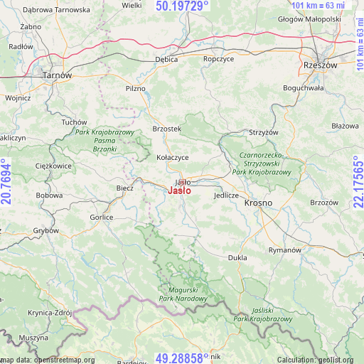
Jasło GPS coordinates[2]
49° 44' 42.216" North, 21° 28' 21.072" East
| Map corner | latitude | longitude |
|---|---|---|
| Upper-left | 50.19729°, | 20.7694° |
| Center: | 49.74506°, | 21.47252° |
| Lower-right: | 49.28858°, | 22.17565° |
| Map W x H: | 101×101 km | = 62.8×62.8mi |
| max Lat: | 54.83135° ⇑93.2% North |
| Jasło: | 49.74506° |
| min Lat: | ⇓6.8% South 49.21328° |
| min Long | Jasło | max Long |
| 14.20249° | 21.47252° | 24.03723° |
| W 78.8%⇐ | ⇒21.2% E |
Elevation
Elevation of Jasło is 231 m = 758 ft, and this is 39.6 m = 130 ft above average elevation for this country.
| Max E: |
974 m = 3196 ft | 29.4% |
| Jasło | 231 m 758 ft | |
| Avg. | 191.4 m = 628 ft | |
Min E: |
-3 m = -10 ft | 70.6% |
See also: Poland elevation on elevation.city.
Geographical zone
Jasło is located in North temperate zone (between Tropic of Cancer and the Arctic Circle). Distance of this North polar circle is 1870 km =1162 mi to North.| Distance of | km | miles | from Jasło |
|---|---|---|---|
| North Pole | 4475.9 | 2781.2 | to North |
| Arctic Circle | 1870 | 1162 | to North |
| Tropic Cancer | 2925.2 | 1817.6 | to South |
| Equator | 5531.1 | 3436.9 | to South |


Nearby cities:
15 places around Jasło: (largest is in red/bold)
• Brzyska
10.4 km =6.5 mi,  325°
325°
• Dębowiec
6.9 km =4.3 mi,  187°
187°
• Frysztak
14.6 km =9.1 mi,  42°
42°
• Jabłonica
11.7 km =7.3 mi,  297°
297°
• Jedlicze
13 km =8.1 mi,  103°
103°
• Kołaczyce
7.5 km =4.7 mi,  338°
338°
• Lipnica Dolna
7.7 km =4.8 mi, 303°
• Osiek Jasielski
12 km =7.5 mi,  174°
174°
• Pielgrzymka
14.6 km =9.1 mi, 189°
• Skołyszyn
9.8 km =6.1 mi,  272°
272°
• Tarnowiec
7.6 km =4.7 mi, 101°
• Trzcinica
4 km =2.5 mi, 266°
• Wojaszówka
14.7 km =9.1 mi,  75°
75°
• Wróblowa
7.2 km =4.5 mi,  313°
313°
• Zarzecze
7.6 km =4.7 mi,  175°
175°
Sources, notices
• [Note1] Compared only with cities in Poland existing in our database
• [Src1] Map data: © OpenStreetMap contributors (CC-BY-SA)
• [Src2] Other city data from geonames.org with taken over terms of usage.
• [Src3] Geographical zone / Annual Mean Temperature by Robert A. Rohde @ Wikipedia
