Kołaczyce geodata
Kołaczyce (Subcarpathian) is a seat of a third-order administrative division; located in Poland in Europe/Warsaw (GMT+2) time zone. With population of 1,316 people, there are 2043 cities with bigger population in this country. Compared to other cities in Poland, 91.5% of cities are located further ↑North; 78.4% of cities are located further ←West and 68.4% of cities have lower elevation than Kołaczyce. Note1


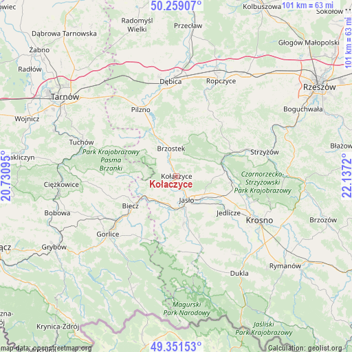
Kołaczyce GPS coordinates[2]
49° 48' 26.748" North, 21° 26' 2.652" East
| Map corner | latitude | longitude |
|---|---|---|
| Upper-left | 50.25907°, | 20.73095° |
| Center: | 49.80743°, | 21.43407° |
| Lower-right: | 49.35153°, | 22.1372° |
| Map W x H: | 100.9×100.9 km | = 62.7×62.7mi |
| max Lat: | 54.83135° ⇑91.5% North |
| Kołaczyce: | 49.80743° |
| min Lat: | ⇓8.5% South 49.21328° |
| min Long | Kołaczyce | max Long |
| 14.20249° | 21.43407° | 24.03723° |
| W 78.4%⇐ | ⇒21.6% E |
Elevation
Elevation of Kołaczyce is 224 m = 735 ft, and this is 32.6 m = 107 ft above average elevation for this country.
| Max E: |
974 m = 3196 ft | 31.6% |
| Kołaczyce | 224 m 735 ft | |
| Avg. | 191.4 m = 628 ft | |
Min E: |
-3 m = -10 ft | 68.4% |
See also: Poland elevation on elevation.city.
Geographical zone
Kołaczyce is located in North temperate zone (between Tropic of Cancer and the Arctic Circle). Distance of this North polar circle is 1863.1 km =1157.7 mi to North.| Distance of | km | miles | from Kołaczyce |
|---|---|---|---|
| North Pole | 4469 | 2776.9 | to North |
| Arctic Circle | 1863.1 | 1157.7 | to North |
| Tropic Cancer | 2932.1 | 1821.9 | to South |
| Equator | 5538.1 | 3441.2 | to South |


Nearby cities:
15 places around Kołaczyce: (largest is in red/bold)
• Biecz
14.6 km =9.1 mi,  237°
237°
• Brzostek
8.2 km =5.1 mi,  348°
348°
• Brzyska
3.6 km =2.2 mi,  297°
297°
• Dębowiec
13.9 km =8.6 mi,  172°
172°
• Frysztak
13.1 km =8.1 mi,  73°
73°
• Jabłonica
7.8 km =4.8 mi,  258°
258°
• Jasło
7.5 km =4.7 mi,  158°
158°
• Jodłowa
13.3 km =8.3 mi, 302°
• Lipnica Dolna
4.5 km =2.8 mi,  233°
233°
• Skołyszyn
9.5 km =5.9 mi, 227°
• Szerzyny
13.4 km =8.3 mi,  270°
270°
• Tarnowiec
13.3 km =8.3 mi,  129°
129°
• Trzcinica
7.3 km =4.5 mi,  189°
189°
• Wróblowa
3.2 km =2 mi, 231°
• Zarzecze
14.9 km =9.3 mi, 166°
Sources, notices
• [Note1] Compared only with cities in Poland existing in our database
• [Src1] Map data: © OpenStreetMap contributors (CC-BY-SA)
• [Src2] Other city data from geonames.org with taken over terms of usage.
• [Src3] Geographical zone / Annual Mean Temperature by Robert A. Rohde @ Wikipedia
