Brzyska geodata
Brzyska (Subcarpathian) is a seat of a third-order administrative division; located in Poland in Europe/Warsaw (GMT+2) time zone. With population of 1,900 people, there are 1552 cities with bigger population in this country. Compared to other cities in Poland, 91% of cities are located further ↑North; 77.9% of cities are located further ←West and 70.6% of cities have lower elevation than Brzyska. Note1


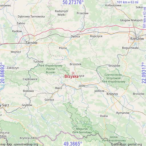
Brzyska GPS coordinates[2]
49° 49' 20.136" North, 21° 23' 24.144" East
| Map corner | latitude | longitude |
|---|---|---|
| Upper-left | 50.27376°, | 20.68692° |
| Center: | 49.82226°, | 21.39004° |
| Lower-right: | 49.3665°, | 22.09317° |
| Map W x H: | 100.9×100.9 km | = 62.7×62.7mi |
| max Lat: | 54.83135° ⇑91% North |
| Brzyska: | 49.82226° |
| min Lat: | ⇓9% South 49.21328° |
| min Long | Brzyska | max Long |
| 14.20249° | 21.39004° | 24.03723° |
| W 77.9%⇐ | ⇒22.1% E |
Elevation
Elevation of Brzyska is 231 m = 758 ft, and this is 39.6 m = 130 ft above average elevation for this country.
| Max E: |
974 m = 3196 ft | 29.4% |
| Brzyska | 231 m 758 ft | |
| Avg. | 191.4 m = 628 ft | |
Min E: |
-3 m = -10 ft | 70.6% |
See also: Poland elevation on elevation.city.
Geographical zone
Brzyska is located in North temperate zone (between Tropic of Cancer and the Arctic Circle). Distance of this North polar circle is 1861.5 km =1156.7 mi to North.| Distance of | km | miles | from Brzyska |
|---|---|---|---|
| North Pole | 4467.3 | 2775.9 | to North |
| Arctic Circle | 1861.5 | 1156.7 | to North |
| Tropic Cancer | 2933.8 | 1823 | to South |
| Equator | 5539.7 | 3442.2 | to South |


Nearby cities:
15 places around Brzyska: (largest is in red/bold)
• Biecz
13.2 km =8.2 mi,  223°
223°
• Binarowa
13.7 km =8.5 mi,  237°
237°
• Brzostek
6.5 km =4 mi,  13°
13°
• Jabłonica
5.5 km =3.4 mi,  234°
234°
• Jasło
10.4 km =6.5 mi,  145°
145°
• Jodłowa
9.7 km =6 mi,  304°
304°
• Kołaczyce
3.6 km =2.2 mi,  117°
117°
• Lipnica Dolna
4.4 km =2.7 mi,  185°
185°
• Ołpiny
13.4 km =8.3 mi,  262°
262°
• Skołyszyn
8.9 km =5.5 mi,  205°
205°
• Strzegocice
15.2 km =9.4 mi,  341°
341°
• Szerzyny
10.4 km =6.5 mi, 261°
• Słotowa
15.4 km =9.6 mi,  333°
333°
• Trzcinica
9 km =5.6 mi,  167°
167°
• Wróblowa
3.7 km =2.3 mi, 169°
Sources, notices
• [Note1] Compared only with cities in Poland existing in our database
• [Src1] Map data: © OpenStreetMap contributors (CC-BY-SA)
• [Src2] Other city data from geonames.org with taken over terms of usage.
• [Src3] Geographical zone / Annual Mean Temperature by Robert A. Rohde @ Wikipedia
