Wodzisław geodata
Wodzisław (Świętokrzyskie) is a seat of a third-order administrative division; located in Poland in Europe/Warsaw (GMT+2) time zone. With population of 1,100 people, there are 2307 cities with bigger population in this country. Compared to other cities in Poland, 66.9% of cities are located further ↑North; 61% of cities are located further ←West and 74.5% of cities have lower elevation than Wodzisław. Note1


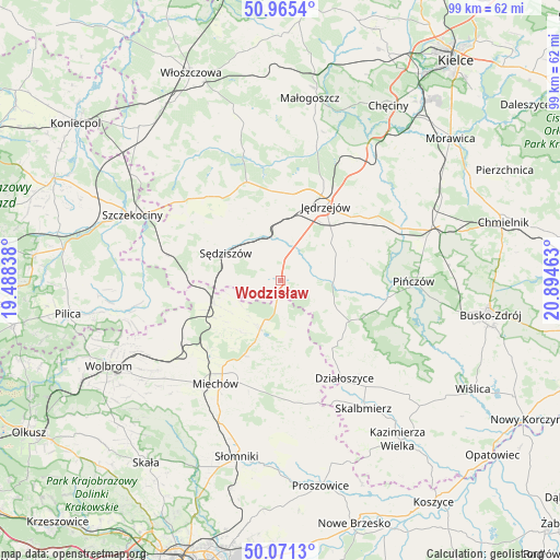
Wodzisław GPS coordinates[2]
50° 31' 13.692" North, 20° 11' 29.4" East
| Map corner | latitude | longitude |
|---|---|---|
| Upper-left | 50.9654°, | 19.48838° |
| Center: | 50.52047°, | 20.1915° |
| Lower-right: | 50.0713°, | 20.89463° |
| Map W x H: | 99.4×99.4 km | = 61.8×61.8mi |
| max Lat: | 54.83135° ⇑66.9% North |
| Wodzisław: | 50.52047° |
| min Lat: | ⇓33.1% South 49.21328° |
| min Long | Wodzisław | max Long |
| 14.20249° | 20.1915° | 24.03723° |
| W 61%⇐ | ⇒39% E |
Elevation
Elevation of Wodzisław is 244 m = 801 ft, and this is 52.6 m = 173 ft above average elevation for this country.
| Max E: |
974 m = 3196 ft | 25.5% |
| Wodzisław | 244 m 801 ft | |
| Avg. | 191.4 m = 628 ft | |
Min E: |
-3 m = -10 ft | 74.5% |
See also: Poland elevation on elevation.city.
Geographical zone
Wodzisław is located in North temperate zone (between Tropic of Cancer and the Arctic Circle). Distance of this North polar circle is 1783.8 km =1108.4 mi to North.| Distance of | km | miles | from Wodzisław |
|---|---|---|---|
| North Pole | 4389.7 | 2727.6 | to North |
| Arctic Circle | 1783.8 | 1108.4 | to North |
| Tropic Cancer | 3011.4 | 1871.2 | to South |
| Equator | 5617.3 | 3490.4 | to South |


Nearby cities:
15 places around Wodzisław: (largest is in red/bold)
• Działoszyce
20.7 km =12.9 mi,  146°
146°
• Imielno
19.5 km =12.1 mi,  68°
68°
• Jędrzejów
15.5 km =9.6 mi,  31°
31°
• Kozłów
12.5 km =7.8 mi,  251°
251°
• Książ Wielki
9.3 km =5.8 mi,  202°
202°
• Kępie
19.3 km =12 mi, 249°
• Marcinowice
14 km =8.7 mi,  261°
261°
• Michałów
19.3 km =12 mi,  98°
98°
• Miechów
21.6 km =13.4 mi,  212°
212°
• Miechów Charsznica
22 km =13.7 mi,  230°
230°
• Nagłowice
18.5 km =11.5 mi,  341°
341°
• Potok Wielki
9.3 km =5.8 mi,  15°
15°
• Racławice
21.9 km =13.6 mi,  171°
171°
• Sędziszów
10.8 km =6.7 mi,  297°
297°
• Słupia
17.7 km =11 mi, 300°
Sources, notices
• [Note1] Compared only with cities in Poland existing in our database
• [Src1] Map data: © OpenStreetMap contributors (CC-BY-SA)
• [Src2] Other city data from geonames.org with taken over terms of usage.
• [Src3] Geographical zone / Annual Mean Temperature by Robert A. Rohde @ Wikipedia
