Nowy Żmigród geodata
Nowy Żmigród (Subcarpathian) is a seat of a third-order administrative division; located in Poland in Europe/Warsaw (GMT+2) time zone. With population of 1,406 people, there are 1948 cities with bigger population in this country. Compared to other cities in Poland, 96.5% of cities are located further ↑North; 79.3% of cities are located further ←West and 88.1% of cities have lower elevation than Nowy Żmigród. Note1


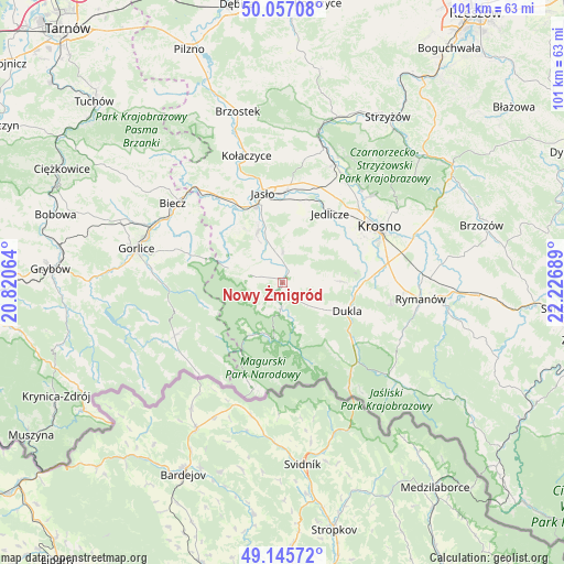
Nowy Żmigród GPS coordinates[2]
49° 36' 12.708" North, 21° 31' 25.536" East
| Map corner | latitude | longitude |
|---|---|---|
| Upper-left | 50.05708°, | 20.82064° |
| Center: | 49.60353°, | 21.52376° |
| Lower-right: | 49.14572°, | 22.22689° |
| Map W x H: | 101.3×101.3 km | = 62.9×62.9mi |
| max Lat: | 54.83135° ⇑96.5% North |
| Nowy Żmigród: | 49.60353° |
| min Lat: | ⇓3.5% South 49.21328° |
| min Long | Nowy Żmigród | max Long |
| 14.20249° | 21.52376° | 24.03723° |
| W 79.3%⇐ | ⇒20.7% E |
Elevation
Elevation of Nowy Żmigród is 309 m = 1014 ft, and this is 117.6 m = 386 ft above average elevation for this country.
| Max E: |
974 m = 3196 ft | 11.9% |
| Nowy Żmigród | 309 m 1014 ft | |
| Avg. | 191.4 m = 628 ft | |
Min E: |
-3 m = -10 ft | 88.1% |
See also: Poland elevation on elevation.city.
Geographical zone
Nowy Żmigród is located in North temperate zone (between Tropic of Cancer and the Arctic Circle). Distance of this North polar circle is 1885.8 km =1171.8 mi to North.| Distance of | km | miles | from Nowy Żmigród |
|---|---|---|---|
| North Pole | 4491.7 | 2791 | to North |
| Arctic Circle | 1885.8 | 1171.8 | to North |
| Tropic Cancer | 2909.5 | 1807.9 | to South |
| Equator | 5515.4 | 3427.1 | to South |


Nearby cities:
15 places around Nowy Żmigród: (largest is in red/bold)
• Chorkówka
11.7 km =7.3 mi,  65°
65°
• Dukla
12.7 km =7.9 mi,  114°
114°
• Dębowiec
10 km =6.2 mi,  333°
333°
• Iwonicz-Zdrój
19.7 km =12.2 mi,  103°
103°
• Jasło
16.2 km =10.1 mi,  346°
346°
• Jedlicze
15.5 km =9.6 mi,  35°
35°
• Krempna
10.4 km =6.5 mi,  189°
189°
• Krosno
20.1 km =12.5 mi,  61°
61°
• Lipinki
18.3 km =11.4 mi,  294°
294°
• Miejsce Piastowe
19.3 km =12 mi,  79°
79°
• Osiek Jasielski
4.6 km =2.9 mi, 326°
• Pielgrzymka
6.2 km =3.9 mi,  282°
282°
• Tarnowiec
14.7 km =9.1 mi,  15°
15°
• Trzcinica
17.3 km =10.7 mi, 333°
• Zarzecze
8.7 km =5.4 mi,  339°
339°
Sources, notices
• [Note1] Compared only with cities in Poland existing in our database
• [Src1] Map data: © OpenStreetMap contributors (CC-BY-SA)
• [Src2] Other city data from geonames.org with taken over terms of usage.
• [Src3] Geographical zone / Annual Mean Temperature by Robert A. Rohde @ Wikipedia
