Prijepolje geodata
Prijepolje (Central Serbia) is a seat of a third-order administrative division; located in Serbia in Europe/Belgrade (GMT+2) time zone. With population of 3 people, there are 363 cities with bigger population in this country. Compared to other cities in Serbia, 87.5% of cities are located further ↑North; 80.7% of cities are located further →East and 92.7% of cities have lower elevation than Prijepolje. Note1


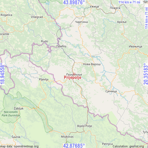
Prijepolje GPS coordinates[2]
43° 23' 23.856" North, 19° 38' 55.32" East
| Map corner | latitude | longitude |
|---|---|---|
| Upper-left | 43.89876°, | 18.94558° |
| Center: | 43.38996°, | 19.6487° |
| Lower-right: | 42.87685°, | 20.35183° |
| Map W x H: | 113.6×113.6 km | = 70.6×70.6mi |
| max Lat: | 46.1° ⇑87.5% North |
| Prijepolje: | 43.38996° |
| min Lat: | ⇓12.5% South 42.25846° |
| min Long | Prijepolje | max Long |
| 18.9276° | 19.6487° | 22.77556° |
| W 19.3%⇐ | ⇒80.7% E |
Elevation
Elevation of Prijepolje is 452 m = 1483 ft, and this is 275.6 m = 904 ft above average elevation for this country.
| Max E: |
1421 m = 4662 ft | 7.3% |
| Prijepolje | 452 m 1483 ft | |
| Avg. | 176.4 m = 579 ft | |
Min E: |
49 m = 161 ft | 92.7% |
See also: Serbia elevation on elevation.city.
Geographical zone
Prijepolje is located in North temperate zone (between Tropic of Cancer and the Arctic Circle). Distance of this Northern Tropic circle is 2218.6 km =1378.6 mi to South.| Distance of | km | miles | from Prijepolje |
|---|---|---|---|
| North Pole | 5182.6 | 3220.3 | to North |
| Arctic Circle | 2576.7 | 1601.1 | to North |
| Tropic Cancer | 2218.6 | 1378.6 | to South |
| Equator | 4824.5 | 2997.8 | to South |


Nearby cities:
15 places around Prijepolje: (largest is in red/bold)
• Arilje
54.1 km =33.6 mi,  41°
41°
• Bajina Bašta
64.9 km =40.3 mi,  354°
354°
• Ivanjica
51.5 km =32 mi,  65°
65°
• Mokra Gora
45.9 km =28.5 mi,  344°
344°
• Nova Varoš
15.3 km =9.5 mi,  59°
59°
• Osječenik
32.1 km =19.9 mi,  147°
147°
• Požega
59.8 km =37.2 mi,  31°
31°
• Priboj
23.7 km =14.7 mi, 335°
• Sjenica
31.2 km =19.4 mi,  114°
114°
• Sokolovica
57.3 km =35.6 mi, 109°
• Sokolovo Brdo
30.9 km =19.2 mi,  155°
155°
• Užice
54.5 km =33.9 mi,  17°
17°
• Zlatibor
37.9 km =23.5 mi,  6°
6°
• Ðurići
52 km =32.3 mi, 338°
• Čajetina
40.3 km =25 mi, 7°
Sources, notices
• [Note1] Compared only with cities in Serbia existing in our database
• [Src1] Map data: © OpenStreetMap contributors (CC-BY-SA)
• [Src2] Other city data from geonames.org with taken over terms of usage.
• [Src3] Geographical zone / Annual Mean Temperature by Robert A. Rohde @ Wikipedia
