Novobureyskiy geodata
Novobureyskiy (Amur Oblast) is a populated place; located in Russia in Asia/Yakutsk (GMT+9) time zone. With population of 8,550 people, there are 1710 cities with bigger population in this country. Compared to other cities in Russia, 78.2% of cities are located further ↑North; 94.3% of cities are located further ←West and 62% of cities have higher elevation than Novobureyskiy. Note1


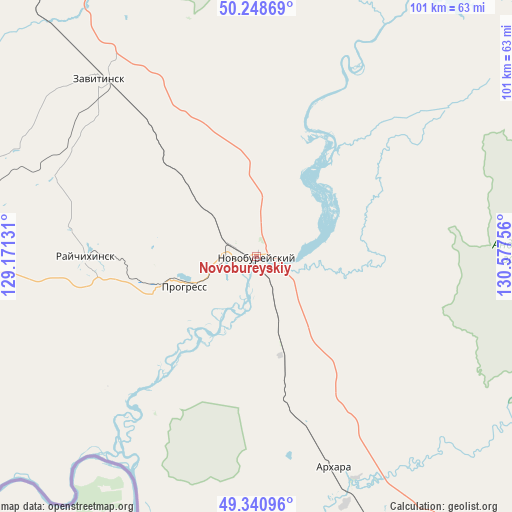
Novobureyskiy GPS coordinates[2]
49° 47' 49.02" North, 129° 52' 27.948" East
| Map corner | latitude | longitude |
|---|---|---|
| Upper-left | 50.24869°, | 129.17131° |
| Center: | 49.79695°, | 129.87443° |
| Lower-right: | 49.34096°, | 130.57756° |
| Map W x H: | 100.9×100.9 km | = 62.7×62.7mi |
| max Lat: | 73.50819° ⇑78.2% North |
| Novobureyskiy: | 49.79695° |
| min Lat: | ⇓21.8% South 41.28413° |
| min Long | Novobureyskiy | max Long |
| -179.12198° | 129.87443° | 179.35046° |
| W 94.3%⇐ | ⇒5.7% E |
Elevation
Elevation of Novobureyskiy is 120 m = 394 ft, and this is 82.6 m = 271 ft below average elevation for this country.
| Max E: |
2518 m = 8261 ft | 62% |
| Avg. | 202.6 m = 665 ft | |
| Novobureyskiy | 120 m = 394 ft | |
Min E: |
-28 m = -92 ft | 38% |
See also: Russia elevation on elevation.city.
Geographical zone
Novobureyskiy is located in North temperate zone (between Tropic of Cancer and the Arctic Circle). Distance of this North polar circle is 1864.3 km =1158.4 mi to North.| Distance of | km | miles | from Novobureyskiy |
|---|---|---|---|
| North Pole | 4470.2 | 2777.7 | to North |
| Arctic Circle | 1864.3 | 1158.4 | to North |
| Tropic Cancer | 2931 | 1821.2 | to South |
| Equator | 5536.9 | 3440.5 | to South |


Nearby cities:
15 places around Novobureyskiy: (largest is in red/bold)
• Arkhara
44.1 km =27.4 mi,  159°
159°
• Bureya
4.7 km =2.9 mi,  290°
290°
• Izvestkovyy
151.6 km =94.2 mi,  126°
126°
• Khingansk
120.9 km =75.1 mi, 127°
• Konstantinovka
136.9 km =85.1 mi,  261°
261°
• Kul’dur
143.4 km =89.1 mi,  117°
117°
• Novoraychikhinsk
20.4 km =12.7 mi,  266°
266°
• Poyarkovo
89.8 km =55.8 mi, 257°
• Raychikhinsk
33.4 km =20.8 mi, 268°
• Romny
110.8 km =68.8 mi,  338°
338°
• Shirokiy
25.8 km =16 mi, 260°
• Talakan
59 km =36.7 mi,  28°
28°
• Tambovka
134.3 km =83.5 mi,  284°
284°
• Yekaterinoslavka
84.2 km =52.3 mi,  319°
319°
• Zavitinsk
46.7 km =29 mi, 318°
Sources, notices
• [Note1] Compared only with cities in Russia existing in our database
• [Src1] Map data: © OpenStreetMap contributors (CC-BY-SA)
• [Src2] Other city data from geonames.org with taken over terms of usage.
• [Src3] Geographical zone / Annual Mean Temperature by Robert A. Rohde @ Wikipedia
