Shirokiy geodata
Shirokiy (Amur Oblast) is a populated place; located in Russia in Asia/Yakutsk (GMT+9) time zone. With population of 1,519 people, there are 4365 cities with bigger population in this country. Compared to other cities in Russia, 78.3% of cities are located further ↑North; 94.1% of cities are located further ←West and 62.9% of cities have lower elevation than Shirokiy. Note1


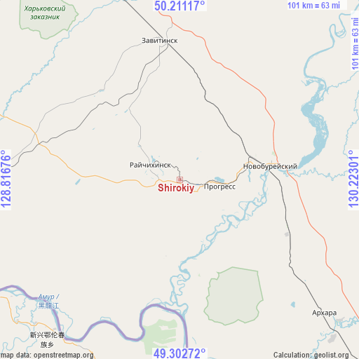
Shirokiy GPS coordinates[2]
49° 45' 32.652" North, 129° 31' 11.568" East
| Map corner | latitude | longitude |
|---|---|---|
| Upper-left | 50.21117°, | 128.81676° |
| Center: | 49.75907°, | 129.51988° |
| Lower-right: | 49.30272°, | 130.22301° |
| Map W x H: | 101×101 km | = 62.8×62.8mi |
| max Lat: | 73.50819° ⇑78.3% North |
| Shirokiy: | 49.75907° |
| min Lat: | ⇓21.7% South 41.28413° |
| min Long | Shirokiy | max Long |
| -179.12198° | 129.51988° | 179.35046° |
| W 94.1%⇐ | ⇒5.9% E |
Elevation
Elevation of Shirokiy is 176 m = 577 ft, and this is 26.6 m = 87 ft below average elevation for this country.
| Max E: |
2518 m = 8261 ft | 37.1% |
| Avg. | 202.6 m = 665 ft | |
| Shirokiy | 176 m = 577 ft | |
Min E: |
-28 m = -92 ft | 62.9% |
See also: Russia elevation on elevation.city.
Geographical zone
Shirokiy is located in North temperate zone (between Tropic of Cancer and the Arctic Circle). Distance of this North polar circle is 1868.5 km =1161 mi to North.| Distance of | km | miles | from Shirokiy |
|---|---|---|---|
| North Pole | 4474.4 | 2780.3 | to North |
| Arctic Circle | 1868.5 | 1161 | to North |
| Tropic Cancer | 2926.8 | 1818.6 | to South |
| Equator | 5532.7 | 3437.9 | to South |


Nearby cities:
15 places around Shirokiy: (largest is in red/bold)
• Arkhara
55.2 km =34.3 mi,  132°
132°
• Belogorsk
148.4 km =92.2 mi,  330°
330°
• Bureya
21.8 km =13.5 mi,  74°
74°
• Khingansk
139.8 km =86.9 mi,  120°
120°
• Konstantinovka
111.1 km =69 mi,  261°
261°
• Novobureyskiy
25.8 km =16 mi,  80°
80°
• Novoraychikhinsk
5.8 km =3.6 mi,  61°
61°
• Poyarkovo
64 km =39.8 mi, 256°
• Raychikhinsk
8.6 km =5.3 mi,  293°
293°
• Romny
108.2 km =67.2 mi,  351°
351°
• Srednebelaya
146.8 km =91.2 mi,  312°
312°
• Talakan
77.5 km =48.2 mi,  43°
43°
• Tambovka
111.3 km =69.2 mi, 289°
• Yekaterinoslavka
74.3 km =46.2 mi,  336°
336°
• Zavitinsk
39.6 km =24.6 mi, 351°
Sources, notices
• [Note1] Compared only with cities in Russia existing in our database
• [Src1] Map data: © OpenStreetMap contributors (CC-BY-SA)
• [Src2] Other city data from geonames.org with taken over terms of usage.
• [Src3] Geographical zone / Annual Mean Temperature by Robert A. Rohde @ Wikipedia
