Talakan geodata
Talakan (Amur Oblast) is a populated place; located in Russia in Asia/Yakutsk (GMT+9) time zone. With population of 6,294 people, there are 2180 cities with bigger population in this country. Compared to other cities in Russia, 77.4% of cities are located further ↑North; 94.4% of cities are located further ←West and 81.6% of cities have lower elevation than Talakan. Note1


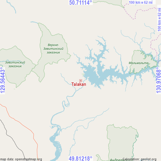
Talakan GPS coordinates[2]
50° 15' 49.608" North, 130° 16' 3.18" East
| Map corner | latitude | longitude |
|---|---|---|
| Upper-left | 50.71114°, | 129.56443° |
| Center: | 50.26378°, | 130.26755° |
| Lower-right: | 49.81218°, | 130.97068° |
| Map W x H: | 100×100 km | = 62.1×62.1mi |
| max Lat: | 73.50819° ⇑77.4% North |
| Talakan: | 50.26378° |
| min Lat: | ⇓22.6% South 41.28413° |
| min Long | Talakan | max Long |
| -179.12198° | 130.26755° | 179.35046° |
| W 94.4%⇐ | ⇒5.6% E |
Elevation
Elevation of Talakan is 269 m = 883 ft, and this is 66.4 m = 218 ft above average elevation for this country.
| Max E: |
2518 m = 8261 ft | 18.4% |
| Talakan | 269 m 883 ft | |
| Avg. | 202.6 m = 665 ft | |
Min E: |
-28 m = -92 ft | 81.6% |
See also: Russia elevation on elevation.city.
Geographical zone
Talakan is located in North temperate zone (between Tropic of Cancer and the Arctic Circle). Distance of this North polar circle is 1812.4 km =1126.2 mi to North.| Distance of | km | miles | from Talakan |
|---|---|---|---|
| North Pole | 4418.3 | 2745.4 | to North |
| Arctic Circle | 1812.4 | 1126.2 | to North |
| Tropic Cancer | 2982.9 | 1853.5 | to South |
| Equator | 5588.8 | 3472.7 | to South |


Nearby cities:
15 places around Talakan: (largest is in red/bold)
• Arkhara
94.2 km =58.5 mi,  187°
187°
• Belogorsk
145.7 km =90.5 mi,  299°
299°
• Bureya
59.8 km =37.2 mi,  212°
212°
• Khingansk
142.7 km =88.7 mi,  152°
152°
• Kul’dur
153.5 km =95.4 mi,  140°
140°
• Novobureyskiy
59 km =36.7 mi, 208°
• Novoraychikhinsk
72 km =44.7 mi,  222°
222°
• Poyarkovo
135.5 km =84.2 mi,  238°
238°
• Raychikhinsk
80.8 km =50.2 mi,  229°
229°
• Romny
85.7 km =53.3 mi,  306°
306°
• Shirokiy
77.5 km =48.2 mi, 223°
• Tambovka
158.4 km =98.4 mi,  263°
263°
• Tyrma
136.2 km =84.6 mi,  100°
100°
• Yekaterinoslavka
83.1 km =51.6 mi,  278°
278°
• Zavitinsk
61.2 km =38 mi,  253°
253°
Sources, notices
• [Note1] Compared only with cities in Russia existing in our database
• [Src1] Map data: © OpenStreetMap contributors (CC-BY-SA)
• [Src2] Other city data from geonames.org with taken over terms of usage.
• [Src3] Geographical zone / Annual Mean Temperature by Robert A. Rohde @ Wikipedia
