Arkhara geodata
Arkhara (Amur Oblast) is a populated place; located in Russia in Asia/Yakutsk (GMT+9) time zone. With population of 10,430 people, there are 1451 cities with bigger population in this country. Compared to other cities in Russia, 78.6% of cities are located further ↑North; 94.4% of cities are located further ←West and 57.2% of cities have lower elevation than Arkhara. Note1


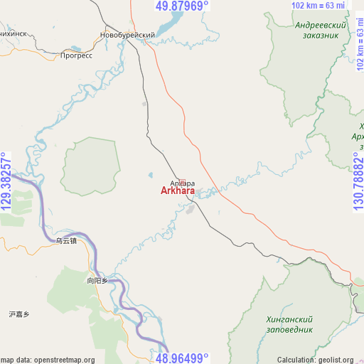
Arkhara GPS coordinates[2]
49° 25' 28.092" North, 130° 5' 8.484" East
| Map corner | latitude | longitude |
|---|---|---|
| Upper-left | 49.87969°, | 129.38257° |
| Center: | 49.42447°, | 130.08569° |
| Lower-right: | 48.96499°, | 130.78882° |
| Map W x H: | 101.7×101.7 km | = 63.2×63.2mi |
| max Lat: | 73.50819° ⇑78.6% North |
| Arkhara: | 49.42447° |
| min Lat: | ⇓21.4% South 41.28413° |
| min Long | Arkhara | max Long |
| -179.12198° | 130.08569° | 179.35046° |
| W 94.4%⇐ | ⇒5.6% E |
Elevation
Elevation of Arkhara is 161 m = 528 ft, and this is 41.6 m = 136 ft below average elevation for this country.
| Max E: |
2518 m = 8261 ft | 42.8% |
| Avg. | 202.6 m = 665 ft | |
| Arkhara | 161 m = 528 ft | |
Min E: |
-28 m = -92 ft | 57.2% |
See also: Russia elevation on elevation.city.
Geographical zone
Arkhara is located in North temperate zone (between Tropic of Cancer and the Arctic Circle). Distance of this North polar circle is 1905.7 km =1184.1 mi to North.| Distance of | km | miles | from Arkhara |
|---|---|---|---|
| North Pole | 4511.6 | 2803.4 | to North |
| Arctic Circle | 1905.7 | 1184.1 | to North |
| Tropic Cancer | 2889.6 | 1795.5 | to South |
| Equator | 5495.5 | 3414.7 | to South |


Nearby cities:
15 places around Arkhara: (largest is in red/bold)
• Birakan
128.1 km =79.6 mi,  112°
112°
• Bureya
47.4 km =29.5 mi,  335°
335°
• Izvestkovyy
117.5 km =73 mi, 114°
• Khingansk
86.8 km =53.9 mi, 112°
• Konstantinovka
152.8 km =94.9 mi,  278°
278°
• Kul’dur
115.2 km =71.6 mi,  102°
102°
• Londoko
145.6 km =90.5 mi, 108°
• Novobureyskiy
44.1 km =27.4 mi, 339°
• Novoraychikhinsk
53.6 km =33.3 mi,  318°
318°
• Poyarkovo
105.8 km =65.7 mi, 282°
• Raychikhinsk
63.4 km =39.4 mi,  309°
309°
• Shirokiy
55.2 km =34.3 mi, 312°
• Talakan
94.2 km =58.5 mi,  7°
7°
• Yekaterinoslavka
126.6 km =78.7 mi,  326°
326°
• Zavitinsk
89.3 km =55.5 mi, 328°
Sources, notices
• [Note1] Compared only with cities in Russia existing in our database
• [Src1] Map data: © OpenStreetMap contributors (CC-BY-SA)
• [Src2] Other city data from geonames.org with taken over terms of usage.
• [Src3] Geographical zone / Annual Mean Temperature by Robert A. Rohde @ Wikipedia
