Konstantinovka geodata
Konstantinovka (Amur Oblast) is a populated place; located in Russia in Asia/Yakutsk (GMT+9) time zone. With population of 5,702 people, there are 2363 cities with bigger population in this country. Compared to other cities in Russia, 78.5% of cities are located further ↑North; 93.8% of cities are located further ←West and 61.4% of cities have higher elevation than Konstantinovka. Note1


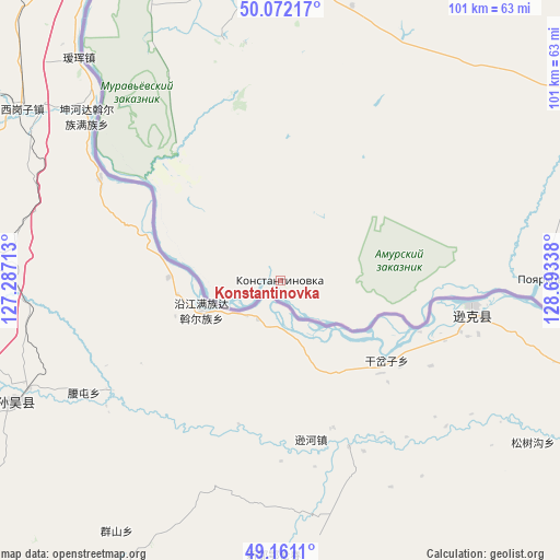
Konstantinovka GPS coordinates[2]
49° 37' 7.536" North, 127° 59' 24.9" East
| Map corner | latitude | longitude |
|---|---|---|
| Upper-left | 50.07217°, | 127.28713° |
| Center: | 49.61876°, | 127.99025° |
| Lower-right: | 49.1611°, | 128.69338° |
| Map W x H: | 101.3×101.3 km | = 62.9×62.9mi |
| max Lat: | 73.50819° ⇑78.5% North |
| Konstantinovka: | 49.61876° |
| min Lat: | ⇓21.5% South 41.28413° |
| min Long | Konstantinovka | max Long |
| -179.12198° | 127.99025° | 179.35046° |
| W 93.8%⇐ | ⇒6.2% E |
Elevation
Elevation of Konstantinovka is 121 m = 397 ft, and this is 81.6 m = 268 ft below average elevation for this country.
| Max E: |
2518 m = 8261 ft | 61.4% |
| Avg. | 202.6 m = 665 ft | |
| Konstantinovka | 121 m = 397 ft | |
Min E: |
-28 m = -92 ft | 38.6% |
See also: Russia elevation on elevation.city.
Geographical zone
Konstantinovka is located in North temperate zone (between Tropic of Cancer and the Arctic Circle). Distance of this North polar circle is 1884.1 km =1170.7 mi to North.| Distance of | km | miles | from Konstantinovka |
|---|---|---|---|
| North Pole | 4490 | 2790 | to North |
| Arctic Circle | 1884.1 | 1170.7 | to North |
| Tropic Cancer | 2911.2 | 1808.9 | to South |
| Equator | 5517.1 | 3428.2 | to South |


Nearby cities:
15 places around Konstantinovka: (largest is in red/bold)
• Arkhara
152.8 km =94.9 mi,  98°
98°
• Belogorsk
148.4 km =92.2 mi,  13°
13°
• Blagoveshchensk
80.2 km =49.8 mi,  336°
336°
• Bureya
132.8 km =82.5 mi,  80°
80°
• Novobureyskiy
136.9 km =85.1 mi, 81°
• Novoraychikhinsk
116.5 km =72.4 mi, 80°
• Poyarkovo
47.8 km =29.7 mi,  88°
88°
• Raychikhinsk
103.8 km =64.5 mi, 79°
• Romny
153.6 km =95.4 mi,  37°
37°
• Seryshevo
166.4 km =103.4 mi, 9°
• Shirokiy
111.1 km =69 mi, 81°
• Srednebelaya
115.6 km =71.8 mi,  0°
0°
• Tambovka
53.7 km =33.4 mi, 5°
• Yekaterinoslavka
115.9 km =72 mi, 43°
• Zavitinsk
117.5 km =73 mi,  62°
62°
Sources, notices
• [Note1] Compared only with cities in Russia existing in our database
• [Src1] Map data: © OpenStreetMap contributors (CC-BY-SA)
• [Src2] Other city data from geonames.org with taken over terms of usage.
• [Src3] Geographical zone / Annual Mean Temperature by Robert A. Rohde @ Wikipedia
