Yekaterinoslavka geodata
Yekaterinoslavka (Amur Oblast) is a populated place; located in Russia in Asia/Yakutsk (GMT+9) time zone. With population of 10,178 people, there are 1484 cities with bigger population in this country. Compared to other cities in Russia, 77.1% of cities are located further ↑North; 94% of cities are located further ←West and 78.2% of cities have lower elevation than Yekaterinoslavka. Note1


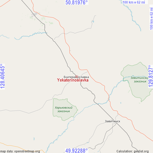
Yekaterinoslavka GPS coordinates[2]
50° 22' 24.384" North, 129° 6' 34.452" East
| Map corner | latitude | longitude |
|---|---|---|
| Upper-left | 50.81976°, | 128.40645° |
| Center: | 50.37344°, | 129.10957° |
| Lower-right: | 49.92288°, | 129.8127° |
| Map W x H: | 99.7×99.7 km | = 62×62mi |
| max Lat: | 73.50819° ⇑77.1% North |
| Yekaterinoslavka: | 50.37344° |
| min Lat: | ⇓22.9% South 41.28413° |
| min Long | Yekaterinoslavk | max Long |
| -179.12198° | 129.10957° | 179.35046° |
| W 94%⇐ | ⇒6% E |
Elevation
Elevation of Yekaterinoslavka is 236 m = 774 ft, and this is 33.4 m = 110 ft above average elevation for this country.
| Max E: |
2518 m = 8261 ft | 21.8% |
| Yekaterinoslavka | 236 m 774 ft | |
| Avg. | 202.6 m = 665 ft | |
Min E: |
-28 m = -92 ft | 78.2% |
See also: Russia elevation on elevation.city.
Geographical zone
Yekaterinoslavka is located in North temperate zone (between Tropic of Cancer and the Arctic Circle). Distance of this North polar circle is 1800.2 km =1118.6 mi to North.| Distance of | km | miles | from Yekaterinoslavka |
|---|---|---|---|
| North Pole | 4406.1 | 2737.8 | to North |
| Arctic Circle | 1800.2 | 1118.6 | to North |
| Tropic Cancer | 2995.1 | 1861.1 | to South |
| Equator | 5601 | 3480.3 | to South |


Nearby cities:
15 places around Yekaterinoslavka: (largest is in red/bold)
• Belogorsk
75.1 km =46.7 mi,  323°
323°
• Blagoveshchensk
111.9 km =69.5 mi,  264°
264°
• Bureya
80.1 km =49.8 mi,  141°
141°
• Konstantinovka
115.9 km =72 mi,  223°
223°
• Novobureyskiy
84.2 km =52.3 mi, 139°
• Novoraychikhinsk
74 km =46 mi,  152°
152°
• Poyarkovo
89.2 km =55.4 mi,  201°
201°
• Raychikhinsk
68.3 km =42.4 mi,  161°
161°
• Romny
40.7 km =25.3 mi,  18°
18°
• Seryshevo
95.1 km =59.1 mi,  327°
327°
• Shirokiy
74.3 km =46.2 mi, 156°
• Srednebelaya
84 km =52.2 mi,  292°
292°
• Talakan
83.1 km =51.6 mi,  98°
98°
• Tambovka
80.8 km =50.2 mi,  247°
247°
• Zavitinsk
37.5 km =23.3 mi, 141°
Sources, notices
• [Note1] Compared only with cities in Russia existing in our database
• [Src1] Map data: © OpenStreetMap contributors (CC-BY-SA)
• [Src2] Other city data from geonames.org with taken over terms of usage.
• [Src3] Geographical zone / Annual Mean Temperature by Robert A. Rohde @ Wikipedia
