Al Lagowa geodata
Al Lagowa (West Kordofan State) is a populated place; located in Sudan in Africa/Khartoum (GMT+2) time zone. With population of 11,024 people, there are 57 cities with bigger population in this country. Compared to other cities in Sudan, 93% of cities are located further ↑North; 83.1% of cities are located further →East and 80.3% of cities have lower elevation than Al Lagowa. Note1


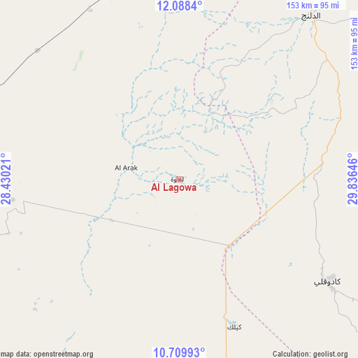
Al Lagowa GPS coordinates[2]
11° 24' 0" North, 29° 7' 59.988" East
| Map corner | latitude | longitude |
|---|---|---|
| Upper-left | 12.0884°, | 28.43021° |
| Center: | 11.4°, | 29.13333° |
| Lower-right: | 10.70993°, | 29.83646° |
| Map W x H: | 153.3×153.3 km | = 95.3×95.3mi |
| max Lat: | 21.06667° ⇑93% North |
| Al Lagowa: | 11.4° |
| min Lat: | ⇓7% South 10.55° |
| min Long | Al Lagowa | max Long |
| 22.44725° | 29.13333° | 37.729° |
| W 16.9%⇐ | ⇒83.1% E |
Elevation
Elevation of Al Lagowa is 566 m = 1857 ft, and this is 116.9 m = 384 ft above average elevation for this country.
| Max E: |
1159 m = 3802 ft | 19.7% |
| Al Lagowa | 566 m 1857 ft | |
| Avg. | 449.1 m = 1473 ft | |
Min E: |
4 m = 13 ft | 80.3% |
See also: Sudan elevation on elevation.city.
Geographical zone
Al Lagowa is located in North Torrid zone (between Equator and Tropic of Cancer). Distance of Equator is 1267.6 km =787.6 mi to South.| Distance of | km | miles | from Al Lagowa |
|---|---|---|---|
| North Pole | 8739.5 | 5430.5 | to North |
| Arctic Circle | 6133.6 | 3811.2 | to North |
| Tropic Cancer | 1338.4 | 831.6 | to North |
| Equator | 1267.6 | 787.6 | to South |


Nearby cities:
15 places around Al Lagowa: (largest is in red/bold)
• Abu Jibeha
228.4 km =141.9 mi,  88°
88°
• Abū Zabad
106.4 km =66.1 mi,  6°
6°
• Al Fūlah
92.2 km =57.3 mi,  293°
293°
• Al Mijlad
158 km =98.2 mi,  255°
255°
• An Nuhūd
163.4 km =101.5 mi,  332°
332°
• Ar Rahad
220.5 km =137 mi,  48°
48°
• Bārah
288.6 km =179.3 mi,  27°
27°
• Dilling
91.6 km =56.9 mi,  37°
37°
• El Daein
327.8 km =203.7 mi,  271°
271°
• El Fula
92.5 km =57.5 mi, 292°
• El Obeid
230.7 km =143.4 mi, 30°
• Kadugli
77.1 km =47.9 mi,  124°
124°
• Talodi
160.6 km =99.8 mi, 122°
• Tandaltī
347.2 km =215.7 mi,  58°
58°
• Umm Ruwaba
281.6 km =175 mi, 53°
Sources, notices
• [Note1] Compared only with cities in Sudan existing in our database
• [Src1] Map data: © OpenStreetMap contributors (CC-BY-SA)
• [Src2] Other city data from geonames.org with taken over terms of usage.
• [Src3] Geographical zone / Annual Mean Temperature by Robert A. Rohde @ Wikipedia
