Arjeplog geodata
Arjeplog (Norrbotten) is a seat of a second-order administrative division; located in Sweden in Europe/Stockholm (GMT+2) time zone. With population of 1,822 people, there are 562 cities with bigger population in this country. Compared to other cities in Sweden, 98.9% of cities are located further ↓South; 84.3% of cities are located further ←West and 99.4% of cities have lower elevation than Arjeplog. Note1


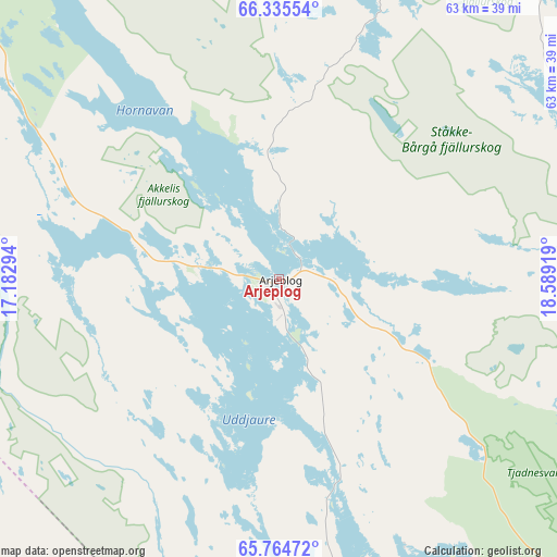
Arjeplog GPS coordinates[2]
66° 3' 6.228" North, 17° 53' 9.816" East
| Map corner | latitude | longitude |
|---|---|---|
| Upper-left | 66.33554°, | 17.18294° |
| Center: | 66.05173°, | 17.88606° |
| Lower-right: | 65.76472°, | 18.58919° |
| Map W x H: | 63.5×63.5 km | = 39.5×39.5mi |
| max Lat: | 67.85572° ⇑1.1% North |
| Arjeplog: | 66.05173° |
| min Lat: | ⇓98.9% South 55.34337° |
| min Long | Arjeplog | max Long |
| 11.1712° | 17.88606° | 24.13676° |
| W 84.3%⇐ | ⇒15.7% E |
Elevation
Elevation of Arjeplog is 426 m = 1398 ft, and this is 343.4 m = 1127 ft above average elevation for this country.
| Max E: |
663 m = 2175 ft | 0.59999999999999% |
| Arjeplog | 426 m 1398 ft | |
| Avg. | 82.6 m = 271 ft | |
Min E: |
-1 m = -3 ft | 99.4% |
See also: Sweden elevation on elevation.city.
Geographical zone
Arjeplog is located in North temperate zone (between Tropic of Cancer and the Arctic Circle). Distance of this North polar circle is 56.9 km =35.4 mi to North.| Distance of | km | miles | from Arjeplog |
|---|---|---|---|
| North Pole | 2662.8 | 1654.6 | to North |
| Arctic Circle | 56.9 | 35.4 | to North |
| Tropic Cancer | 4738.3 | 2944.2 | to South |
| Equator | 7344.3 | 4563.5 | to South |


Nearby cities:
15 places around Arjeplog: (largest is in red/bold)
• Arvidsjaur
77.7 km =48.3 mi,  131°
131°
• Björkvik
122.3 km =76 mi,  239°
239°
• Guojkkasuoluoj
46 km =28.6 mi,  167°
167°
• Jokkmokk
106.2 km =66 mi,  54°
54°
• Jörn
148.3 km =92.1 mi,  138°
138°
• Malå
104.1 km =64.7 mi,  157°
157°
• Norsjö
146.5 km =91 mi,  149°
149°
• Sorsele
59.6 km =37 mi,  195°
195°
• Storuman
112 km =69.6 mi, 198°
• Söderfors
137.5 km =85.4 mi,  176°
176°
• Vidsel
121.7 km =75.6 mi,  101°
101°
• Vuollerim
129.7 km =80.6 mi,  71°
71°
• Älvsbyn
147.7 km =91.8 mi,  106°
106°
• Ånäset
152.3 km =94.6 mi,  116°
116°
• Östansjö
17 km =10.6 mi,  285°
285°
Sources, notices
• [Note1] Compared only with cities in Sweden existing in our database
• [Src1] Map data: © OpenStreetMap contributors (CC-BY-SA)
• [Src2] Other city data from geonames.org with taken over terms of usage.
• [Src3] Geographical zone / Annual Mean Temperature by Robert A. Rohde @ Wikipedia
