Louga geodata
Louga is a seat of a first-order administrative division; located in Senegal in Africa/Dakar (GMT+0) time zone. With population of 67,154 people, there are 11 cities with bigger population in this country. Compared to other cities in Senegal, 90% of cities are located further ↓South; 51.7% of cities are located further ←West and 85% of cities have lower elevation than Louga. Note1


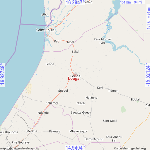
Louga GPS coordinates[2]
15° 37' 7.212" North, 16° 13' 27.696" West
| Map corner | latitude | longitude |
|---|---|---|
| Upper-left | 16.2947°, | -16.92749° |
| Center: | 15.61867°, | -16.22436° |
| Lower-right: | 14.9404°, | -15.52124° |
| Map W x H: | 150.6×150.6 km | = 93.6×93.6mi |
| max Lat: | 16.51293° ⇑10% North |
| Louga: | 15.61867° |
| min Lat: | ⇓90% South 12.485° |
| min Long | Louga | max Long |
| -17.47581° | -16.22436° | -12.18076° |
| W 51.7%⇐ | ⇒48.3% E |
Elevation
Elevation of Louga is 42 m = 138 ft, and this is 17.5 m = 57 ft above average elevation for this country.
| Max E: |
127 m = 417 ft | 15% |
| Louga | 42 m 138 ft | |
| Avg. | 24.5 m = 80 ft | |
Min E: |
0 m = 0 ft | 85% |
See also: Louga elevation on elevation.city.
Geographical zone
Louga is located in North Torrid zone (between Equator and Tropic of Cancer). Distance of this Northern Tropic circle is 869.3 km =540.2 mi to North.| Distance of | km | miles | from Louga |
|---|---|---|---|
| North Pole | 8270.4 | 5139 | to North |
| Arctic Circle | 5664.5 | 3519.8 | to North |
| Tropic Cancer | 869.3 | 540.2 | to North |
| Equator | 1736.6 | 1079.1 | to South |


Nearby cities:
15 places around Louga: (largest is in red/bold)
• Dara
85.2 km =52.9 mi,  110°
110°
• Diourbel
108 km =67.1 mi,  181°
181°
• Guéoul
20.2 km =12.6 mi,  221°
221°
• Kayar
123.6 km =76.8 mi,  230°
230°
• Khombole
107.6 km =66.9 mi,  208°
208°
• Mbaké
98.2 km =61 mi,  159°
159°
• Mékhé
70.8 km =44 mi, 216°
• Ndibène Dahra
86.2 km =53.6 mi, 111°
• Richard-Toll
109.2 km =67.9 mi,  30°
30°
• Rosso
100.1 km =62.2 mi, 27°
• Saint-Louis
52.7 km =32.7 mi,  327°
327°
• Thiès
119 km =73.9 mi, 219°
• Thiès Nones
122.4 km =76.1 mi, 220°
• Tiébo
109.6 km =68.1 mi, 180°
• Touba
93 km =57.8 mi, 156°
Sources, notices
• [Note1] Compared only with cities in Senegal existing in our database
• [Src1] Map data: © OpenStreetMap contributors (CC-BY-SA)
• [Src2] Other city data from geonames.org with taken over terms of usage.
• [Src3] Geographical zone / Annual Mean Temperature by Robert A. Rohde @ Wikipedia
