Guéoul geodata
Guéoul (Louga) is a populated place; located in Senegal in Africa/Dakar (GMT+0) time zone. With population of 10,918 people, there are 37 cities with bigger population in this country. Compared to other cities in Senegal, 85% of cities are located further ↓South; 60% of cities are located further →East and 81.7% of cities have lower elevation than Guéoul. Note1


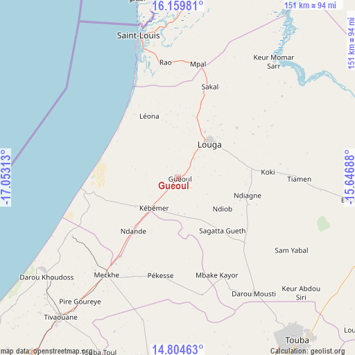
Guéoul GPS coordinates[2]
15° 28' 59.988" North, 16° 21' 0" West
| Map corner | latitude | longitude |
|---|---|---|
| Upper-left | 16.15981°, | -17.05313° |
| Center: | 15.48333°, | -16.35° |
| Lower-right: | 14.80463°, | -15.64688° |
| Map W x H: | 150.7×150.7 km | = 93.6×93.6mi |
| max Lat: | 16.51293° ⇑15% North |
| Guéoul: | 15.48333° |
| min Lat: | ⇓85% South 12.485° |
| min Long | Guéoul | max Long |
| -17.47581° | -16.35° | -12.18076° |
| W 40%⇐ | ⇒60% E |
Elevation
Elevation of Guéoul is 41 m = 135 ft, and this is 16.5 m = 54 ft above average elevation for this country.
| Max E: |
127 m = 417 ft | 18.3% |
| Guéoul | 41 m 135 ft | |
| Avg. | 24.5 m = 80 ft | |
Min E: |
0 m = 0 ft | 81.7% |
See also: Senegal elevation on elevation.city.
Geographical zone
Guéoul is located in North Torrid zone (between Equator and Tropic of Cancer). Distance of this Northern Tropic circle is 884.3 km =549.5 mi to North.| Distance of | km | miles | from Guéoul |
|---|---|---|---|
| North Pole | 8285.5 | 5148.4 | to North |
| Arctic Circle | 5679.6 | 3529.1 | to North |
| Tropic Cancer | 884.3 | 549.5 | to North |
| Equator | 1721.6 | 1069.8 | to South |


Nearby cities:
15 places around Guéoul: (largest is in red/bold)
• Dara
94.5 km =58.7 mi,  99°
99°
• Diourbel
93.6 km =58.2 mi,  172°
172°
• Kayar
103.7 km =64.4 mi,  232°
232°
• Khombole
88.1 km =54.7 mi,  205°
205°
• Louga
20.2 km =12.6 mi,  41°
41°
• Mbaké
90.5 km =56.2 mi,  148°
148°
• Mékhé
50.8 km =31.6 mi,  215°
215°
• Ndibène Dahra
95.1 km =59.1 mi, 100°
• Pout
110 km =68.4 mi, 223°
• Rosso
119.7 km =74.4 mi,  29°
29°
• Saint-Louis
61.3 km =38.1 mi,  345°
345°
• Thiès
98.9 km =61.5 mi, 218°
• Thiès Nones
102.2 km =63.5 mi, 220°
• Tiébo
95.3 km =59.2 mi, 172°
• Touba
86.4 km =53.7 mi,  144°
144°
Sources, notices
• [Note1] Compared only with cities in Senegal existing in our database
• [Src1] Map data: © OpenStreetMap contributors (CC-BY-SA)
• [Src2] Other city data from geonames.org with taken over terms of usage.
• [Src3] Geographical zone / Annual Mean Temperature by Robert A. Rohde @ Wikipedia
