Tonj geodata
Tonj is a seat of a first-order administrative division; located in South Sudan in Africa/Juba (GMT+2) time zone. With population of 17,338 people, there are 12 cities with bigger population in this country. Compared to other cities in South Sudan, 54.5% of cities are located further ↑North; 72.7% of cities are located further →East and 63.6% of cities have lower elevation than Tonj. Note1


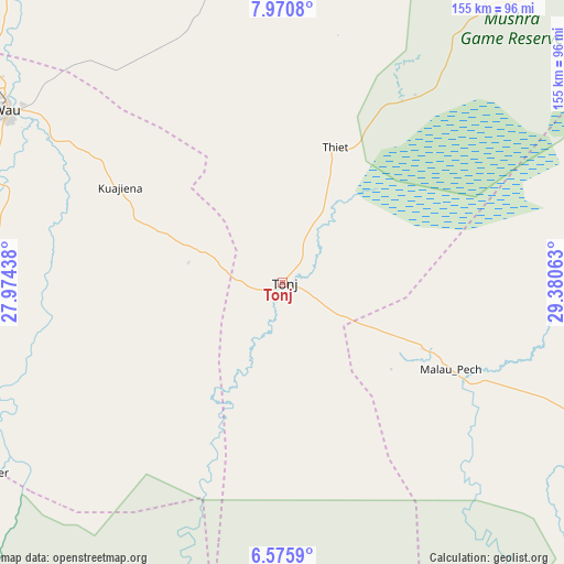
Tonj GPS coordinates[2]
7° 16' 26.004" North, 28° 40' 39" East
| Map corner | latitude | longitude |
|---|---|---|
| Upper-left | 7.9708°, | 27.97438° |
| Center: | 7.27389°, | 28.6775° |
| Lower-right: | 6.5759°, | 29.38063° |
| Map W x H: | 155.1×155.1 km | = 96.4×96.4mi |
| max Lat: | 11.7431° ⇑54.5% North |
| Tonj: | 7.27389° |
| min Lat: | ⇓45.5% South 3.86512° |
| min Long | Tonj | max Long |
| 25.67833° | 28.6775° | 33.92621° |
| W 27.3%⇐ | ⇒72.7% E |
Elevation
Elevation of Tonj is 444 m = 1457 ft, and this is 44.9 m = 147 ft below average elevation for this country.
| Max E: |
836 m = 2743 ft | 36.4% |
| Avg. | 488.9 m = 1604 ft | |
| Tonj | 444 m = 1457 ft | |
Min E: |
392 m = 1286 ft | 63.6% |
See also: South Sudan elevation on elevation.city.
Geographical zone
Tonj is located in North Torrid zone (between Equator and Tropic of Cancer). Distance of Equator is 808.8 km =502.6 mi to South.| Distance of | km | miles | from Tonj |
|---|---|---|---|
| North Pole | 9198.3 | 5715.6 | to North |
| Arctic Circle | 6592.4 | 4096.3 | to North |
| Tropic Cancer | 1797.1 | 1116.7 | to North |
| Equator | 808.8 | 502.6 | to South |


Nearby cities:
15 places around Tonj: (largest is in red/bold)
• Aweil
217.7 km =135.3 mi,  319°
319°
• Bentiu
252.7 km =157 mi,  29°
29°
• Cueibet
68.5 km =42.6 mi,  113°
113°
• Gogrial
153.8 km =95.6 mi,  335°
335°
• Kuacjok
137.8 km =85.6 mi,  326°
326°
• Leer
197.7 km =122.8 mi,  54°
54°
• Maridi
276.3 km =171.7 mi,  161°
161°
• Mayen Abun
210.3 km =130.7 mi,  350°
350°
• Mundri
281.1 km =174.7 mi,  139°
139°
• Rumbek
122 km =75.8 mi,  115°
115°
• Tambura
229.2 km =142.4 mi,  215°
215°
• Wau
89.5 km =55.6 mi,  302°
302°
• Winejok
228.5 km =142 mi, 327°
• Yambio
302.2 km =187.8 mi,  185°
185°
• Yirol
216.4 km =134.5 mi, 111°
Sources, notices
• [Note1] Compared only with cities in South Sudan existing in our database
• [Src1] Map data: © OpenStreetMap contributors (CC-BY-SA)
• [Src2] Other city data from geonames.org with taken over terms of usage.
• [Src3] Geographical zone / Annual Mean Temperature by Robert A. Rohde @ Wikipedia
