Wau geodata
Wau is a seat of a first-order administrative division; located in South Sudan in Africa/Juba (GMT+2) time zone. With population of 127,384 people, there are 3 cities with bigger population in this country. Compared to other cities in South Sudan, 51.5% of cities are located further ↑North; 84.8% of cities are located further →East and 60.6% of cities have lower elevation than Wau. Note1


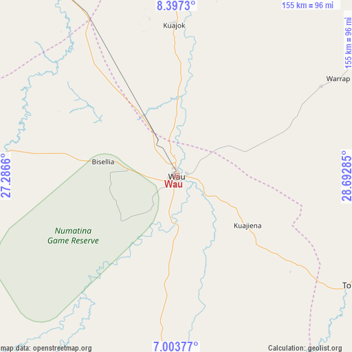
Wau GPS coordinates[2]
7° 42' 3.996" North, 27° 59' 22.992" East
| Map corner | latitude | longitude |
|---|---|---|
| Upper-left | 8.3973°, | 27.2866° |
| Center: | 7.70111°, | 27.98972° |
| Lower-right: | 7.00377°, | 28.69285° |
| Map W x H: | 154.9×154.9 km | = 96.3×96.3mi |
| max Lat: | 11.7431° ⇑51.5% North |
| Wau: | 7.70111° |
| min Lat: | ⇓48.5% South 3.86512° |
| min Long | Wau | max Long |
| 25.67833° | 27.98972° | 33.92621° |
| W 15.2%⇐ | ⇒84.8% E |
Elevation
Elevation of Wau is 440 m = 1444 ft, and this is 48.9 m = 160 ft below average elevation for this country.
| Max E: |
836 m = 2743 ft | 39.4% |
| Avg. | 488.9 m = 1604 ft | |
| Wau | 440 m = 1444 ft | |
Min E: |
392 m = 1286 ft | 60.6% |
See also: Wau elevation on elevation.city.
Geographical zone
Wau is located in North Torrid zone (between Equator and Tropic of Cancer). Distance of Equator is 856.3 km =532.1 mi to South.| Distance of | km | miles | from Wau |
|---|---|---|---|
| North Pole | 9150.8 | 5686 | to North |
| Arctic Circle | 6544.9 | 4066.8 | to North |
| Tropic Cancer | 1749.6 | 1087.2 | to North |
| Equator | 856.3 | 532.1 | to South |


Nearby cities:
15 places around Wau: (largest is in red/bold)
• Aweil
135.1 km =83.9 mi,  330°
330°
• Bentiu
263.6 km =163.8 mi,  48°
48°
• Cueibet
157.5 km =97.9 mi,  118°
118°
• Gogrial
93.3 km =58 mi,  7°
7°
• Kuacjok
66.9 km =41.6 mi,  359°
359°
• Leer
246.1 km =152.9 mi,  74°
74°
• Maridi
350.1 km =217.5 mi,  152°
152°
• Mayen Abun
164.3 km =102.1 mi, 13°
• Pariang
329.4 km =204.7 mi,  41°
41°
• Raja
268.3 km =166.7 mi,  288°
288°
• Rumbek
211.1 km =131.2 mi, 118°
• Tambura
240.7 km =149.6 mi,  193°
193°
• Tonj
89.5 km =55.6 mi, 122°
• Winejok
152.9 km =95 mi,  342°
342°
• Yirol
304.8 km =189.4 mi,  114°
114°
Sources, notices
• [Note1] Compared only with cities in South Sudan existing in our database
• [Src1] Map data: © OpenStreetMap contributors (CC-BY-SA)
• [Src2] Other city data from geonames.org with taken over terms of usage.
• [Src3] Geographical zone / Annual Mean Temperature by Robert A. Rohde @ Wikipedia
