Cueibet geodata
Cueibet (Gok) is a seat of a first-order administrative division; located in South Sudan in Africa/Juba (GMT+2) time zone. In our database, there are 19 cities with bigger population. Compared to other cities in South Sudan, 57.6% of cities are located further ↑North; 69.7% of cities are located further →East and 57.6% of cities have higher elevation than Cueibet. Note1


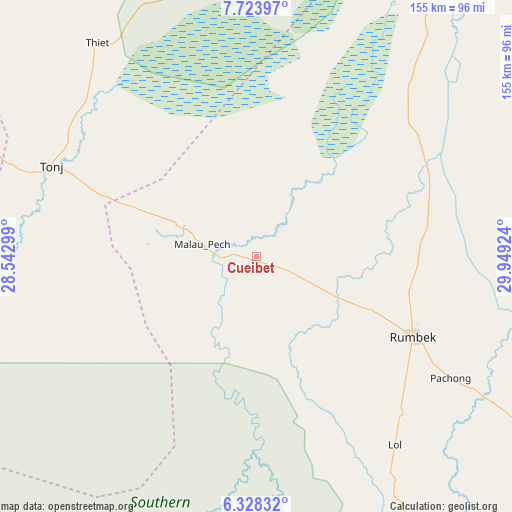
Cueibet GPS coordinates[2]
7° 1' 36.012" North, 29° 14' 45.996" East
| Map corner | latitude | longitude |
|---|---|---|
| Upper-left | 7.72397°, | 28.54299° |
| Center: | 7.02667°, | 29.24611° |
| Lower-right: | 6.32832°, | 29.94924° |
| Map W x H: | 155.2×155.2 km | = 96.4×96.4mi |
| max Lat: | 11.7431° ⇑57.6% North |
| Cueibet: | 7.02667° |
| min Lat: | ⇓42.4% South 3.86512° |
| min Long | Cueibet | max Long |
| 25.67833° | 29.24611° | 33.92621° |
| W 30.3%⇐ | ⇒69.7% E |
Elevation
Elevation of Cueibet is 423 m = 1388 ft, and this is 65.9 m = 216 ft below average elevation for this country.
| Max E: |
836 m = 2743 ft | 57.6% |
| Avg. | 488.9 m = 1604 ft | |
| Cueibet | 423 m = 1388 ft | |
Min E: |
392 m = 1286 ft | 42.4% |
See also: South Sudan elevation on elevation.city.
Geographical zone
Cueibet is located in North Torrid zone (between Equator and Tropic of Cancer). Distance of Equator is 781.3 km =485.5 mi to South.| Distance of | km | miles | from Cueibet |
|---|---|---|---|
| North Pole | 9225.8 | 5732.6 | to North |
| Arctic Circle | 6619.9 | 4113.4 | to North |
| Tropic Cancer | 1824.6 | 1133.8 | to North |
| Equator | 781.3 | 485.5 | to South |


Nearby cities:
15 places around Cueibet: (largest is in red/bold)
• Aweil
280.9 km =174.5 mi,  313°
313°
• Ayod
267.7 km =166.3 mi,  62°
62°
• Bentiu
255.4 km =158.7 mi,  13°
13°
• Bor
271.1 km =168.5 mi,  109°
109°
• Gogrial
209.7 km =130.3 mi,  323°
323°
• Kuacjok
199 km =123.7 mi, 315°
• Leer
172.8 km =107.4 mi,  34°
34°
• Maridi
235.9 km =146.6 mi,  173°
173°
• Mayen Abun
254.7 km =158.3 mi,  337°
337°
• Mundri
221.5 km =137.6 mi,  147°
147°
• Rumbek
53.5 km =33.2 mi,  117°
117°
• Tambura
252.7 km =157 mi,  231°
231°
• Tonj
68.5 km =42.6 mi,  293°
293°
• Wau
157.5 km =97.9 mi,  298°
298°
• Yirol
147.9 km =91.9 mi, 110°
Sources, notices
• [Note1] Compared only with cities in South Sudan existing in our database
• [Src1] Map data: © OpenStreetMap contributors (CC-BY-SA)
• [Src2] Other city data from geonames.org with taken over terms of usage.
• [Src3] Geographical zone / Annual Mean Temperature by Robert A. Rohde @ Wikipedia
