Mhlume geodata
Mhlume (Lubombo) is a populated place; located in Eswatini in Africa/Mbabane (GMT+2) time zone. With population of 8,652 people, there are 5 cities with bigger population in this country. Compared to other cities in Eswatini, 81.8% of cities are located further ↓South; 77.3% of cities are located further ←West and 86.4% of cities have higher elevation than Mhlume. Note1


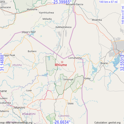
Mhlume GPS coordinates[2]
26° 1' 59.988" South, 31° 51' 0" East
| Map corner | latitude | longitude |
|---|---|---|
| Upper-left | -25.39985°, | 31.14688° |
| Center: | -26.03333°, | 31.85° |
| Lower-right: | -26.6634°, | 32.55313° |
| Map W x H: | 140.5×140.5 km | = 87.3×87.3mi |
| max Lat: | -25.82659° ⇑18.2% North |
| Mhlume: | -26.03333° |
| min Lat: | ⇓81.8% South -27.31005° |
| min Long | Mhlume | max Long |
| 31.01667° | 31.85° | 31.95° |
| W 77.3%⇐ | ⇒22.7% E |
Elevation
Elevation of Mhlume is 258 m = 846 ft, and this is 420.5 m = 1380 ft below average elevation for this country.
| Max E: |
1317 m = 4321 ft | 86.4% |
| Avg. | 678.5 m = 2226 ft | |
| Mhlume | 258 m = 846 ft | |
Min E: |
109 m = 358 ft | 13.6% |
See also: Eswatini elevation on elevation.city.
Geographical zone
Mhlume is located in South temperate zone (between Tropic of Capricorn and the Antarctic Circle). Distance of this Southern Tropic circle is 288.7 km =179.4 mi to North.| Distance of | km | miles | from Mhlume |
|---|---|---|---|
| Equator | 2894.6 | 1798.6 | to North |
| Tropic Capricorn | 288.7 | 179.4 | to North |
| Antarctic Circle | 4506.5 | 2800.2 | to South |
| South Pole | 7112.4 | 4419.4 | to South |


Nearby cities:
15 places around Mhlume: (largest is in red/bold)
• Big Bend
87.5 km =54.4 mi,  174°
174°
• Bulembu
72 km =44.7 mi,  275°
275°
• Darkton
84.5 km =52.5 mi,  254°
254°
• Kwaluseni
71.8 km =44.6 mi,  225°
225°
• Lobamba
80.8 km =50.2 mi, 233°
• Malkerns
89.1 km =55.4 mi, 228°
• Manzini
69.8 km =43.4 mi,  222°
222°
• Mbabane
78.1 km =48.5 mi, 246°
• Mhlambanyatsi
95.1 km =59.1 mi,  240°
240°
• Ntfonjeni
57.1 km =35.5 mi,  293°
293°
• Piggs Peak
60.8 km =37.8 mi, 277°
• Sidvokodvo
78.8 km =49 mi,  212°
212°
• Siteki
47.6 km =29.6 mi, 168°
• Tshaneni
14.4 km =8.9 mi, 292°
• Vuvulane
5.3 km =3.3 mi,  149°
149°
Sources, notices
• [Note1] Compared only with cities in Eswatini existing in our database
• [Src1] Map data: © OpenStreetMap contributors (CC-BY-SA)
• [Src2] Other city data from geonames.org with taken over terms of usage.
• [Src3] Geographical zone / Annual Mean Temperature by Robert A. Rohde @ Wikipedia
